Bácsalmás District
This article needs additional citations for verification. (October 2016) |
Bácsalmás District
Bácsalmási járás | |
|---|---|
 Coat of arms | |
 | |
| Country | |
| County | Bács-Kiskun |
| District seat | Bácsalmás |
| Area | |
| • Total | 561.71 km2 (216.88 sq mi) |
| Area rank | 8th in Bács-Kiskun |
| Population (2011 census) | |
| • Total | 20,094 |
| • Rank | 9th in Bács-Kiskun |
| • Density | 52/km2 (130/sq mi) |
Bácsalmás (Hungarian: Bácsalmási járás; German: Kreis Almasch) is a district in southern part of Bács-Kiskun County. Bácsalmás is also the name of the town where the district seat is found. The district is located in the Southern Great Plain Statistical Region.
Geography[]
Bácsalmás District borders with Jánoshalma District and Kiskunhalas District to the north, the Serbian districts of North Bačka to the east and West Bačka to the south, Baja District to the west and north. The number of the inhabited places in Bácsalmás District is 10.
Municipalities[]
The district has 1 town, 1 large village and 8 villages. (ordered by population, as of 1 January 2013)[1]
- Bácsalmás (6,811) – district seat
- Bácsbokod (2,656)
- Bácsborsód (1,179)
- Bácsszőlős (349)
- Csikéria (868)
- Katymár (1,951)
- Kunbaja (1,562)
- Madaras (2,903)
- Mátételke (476)
- Tataháza (1,228)
The bolded municipality is city, italics municipality is large village.
Demographics[]
Religion in Bácsalmás District (2011 census)
In 2011, it had a population of 20,094 and the population density was 38/km².
| Year | County population[2] | Change |
|---|---|---|
| 2011 | 20,094 | n/a |
Ethnicity[]
Besides the Hungarian majority, the main minorities are the German (approx. 1,100), Croat (550), Roma (300) and Serb (100).
Total population (2011 census): 20,094
Ethnic groups (2011 census):[3] Identified themselves: 19,600 persons:
- Hungarians: 17,512 (89.35%)
- Germans: 1,062 (5.42%)
- Croats: 568 (2.90%)
- Gypsies: 291 (1.48%)
- Others and indefinable: 167 (0.85%)
Approx. 500 persons in Bácsalmás District did not declare their ethnic group at the 2011 census.
Religion[]
Religious adherence in the county according to 2011 census:[4]
- Catholic – 12,041 (Roman Catholic – 12,019; Greek Catholic – 21);
- Reformed – 1,048;
- Evangelical – 36;
- other religions – 169;
- Non-religious – 2,016;
- Atheism – 138;
- Undeclared – 4,646.
Gallery[]
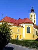
Bácsalmás, the district seat

Latinovits Mansion in Bácsborsód
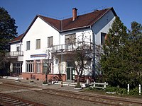
Bácsbokod-Bácsborsód railway station
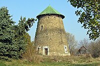
Windmill near Tataháza


See also[]
References[]
- ^ A KSH 2013. évi helységnévkönyve
- ^ népesség.com, "Bácsalmási járás népessége"
- ^ 4.1.6.1 A népesség nemzetiség szerint, 2011, (in Hungarian) [1]
- ^ 4.1.7.1 A népesség vallás, felekezet szerint, 2011, (in Hungarian) [2]
External links[]
Coordinates: 46°07′00″N 19°20′00″E / 46.1167°N 19.3333°E

This Bács-Kiskun location article is a stub. You can help Wikipedia by . |
- Districts in Bács-Kiskun County
- Bács-Kiskun County geography stubs