Babadağ (mountain)
| Babadağ | |
|---|---|
 | |
| Highest point | |
| Elevation | 1,969 m (6,460 ft)[1] |
| Prominence | 1,763 m (5,784 ft)[1][2] |
| Listing | Ultra |
| Coordinates | 36°31′42″N 29°11′06″E / 36.52833°N 29.18500°ECoordinates: 36°31′42″N 29°11′06″E / 36.52833°N 29.18500°E[1] |
| Geography | |
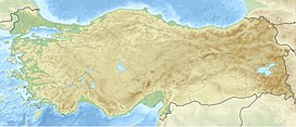 Babadağ Location in Turkey | |
| Location | Fethiye, Muğla Province, Turkey |

Babadağ (ancient Mount Anticragus, Ancient Greek: Ἀντίκραγος) is a mountain near Fethiye, in Muğla Province, southwest Turkey.[3][4]
The mountain has a principal summit at an elevation of 1,969 metres (6,460 ft) and a second one called "Karatepe" at an elevation of 1,400 metres (4,593 ft). These two summits face each other and are separated by a flood valley, which led to the term "mountain range" to be used in some sources in association with Babadağ. The mass is composed mainly of limestone. It is noted for its rich flora, including the endemic Acer undulatum, and forests of Cedrus libani.
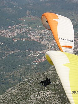
It is also notable for the proximity of its summit to the sea (less than 5 km) which is one of the factors that make it particularly suitable and popular for paragliding.
Babadağ, Mount Cragus and Anticragus[]
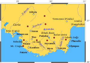
In ancient times, Mount Cragus (also spelled Mount Cragos or Mount Kragus) was a principal mountain of ancient Lycia, although ancient names are sometimes difficult to match with the features observed today.
Strabo (p. 665), whose description proceeds from west to east, after the promontory Telmissus, mentions "Anticragus", on which is Carmylessus, and then Cragus, which has eight "summits" (or he may have meant "capes"), and a city of the same name; Cragus (Lycia). Another city, Pinara, in the interior, was at the base of Cragus.
There are coins of the town Cragus of the Roman imperial period, with the epigraph Λυκιων Κρ. or Κρα. or Κραγ. The range of Anticragus and Cragus is represented in the map in Spratt and Forbes[5] as running south from the neighbourhood of Telmissus, and forming the western boundary of the lower basin of the river Xanthus. The southern part is Cragus. The direction of the range shows that it must abut on the sea in bold headlands. In Francis Beaufort's map of the coast of Karamania, the Anticragus is marked 6000 feet high. Beaufort's examination of this coast began at , which means "the Seven Capes", a knot of high and rugged mountains that appear to have been the ancient Mount Cragus of Lycia.[6] The ruins of Pinara are where Strabo describes them, on the east side of this range, about halfway between Telmissus and the termination of the range on the south coast. There is a pass leading between the summits of Cragus and Anticragus. Between the two chief peaks is a plain 4000 feet above the sea; and above it rises the highest peak of Cragus, more than 2500 feet above this elevated plain. The first half of the ascent from the plain is through a thick forest, and the remainder over bare rock. From the summit there is a view of the whole plain of Xanthus, and of the gorges of the , which lies east of it. The side towards the sea is so steep, that from this lofty summit the waves are seen breaking white against the base of this precipitous mountain mass.[7] It appears that Strabo is right when he describes a valley or depression as separating Anticragus and Cragus; and the highest part, which towers above the sea at the Seven Capes, seems to be the eight summits that Strabo speaks of. There was a promontory Cragus, according to Scylax and Pliny the Elder (v. 27), which must be the Seven Capes. The Hiera Acra of the Stadiasmus seems also to be the Seven Capes. The position of the Cragus between Xanthus and Telmissus is mentioned by Pomponius Mela (i. 15), and he also probably means the same striking part of the range.
The rocks and forests of Cragus were embellished by poetic fictions as the occasional residence of Diana.[8] Here, according to the authority quoted by Stephanus of Byzantium (s. v. Κράγος), were the so-called θεῶν ἀγρίων ἄντρα.
See also[]
- Mount Cragus
- Cragus (Lycia)
- Telmissus
- Pinara
- Patara (Lycia)
- List of Ultras of West Asia
- Butterfly Valley, Fethiye
References[]
- ^ Jump up to: a b c Turkey - Ultra page peaklist.org. Retrieved 14 October 2011.
- ^ "Babadag, Turkey" on Peakbagger.com. Retrieved 14 October 2011.
- ^ Richard Talbert, ed. (2000). Barrington Atlas of the Greek and Roman World. Princeton University Press. p. 65, and directory notes accompanying.
- ^ Lund University. Digital Atlas of the Roman Empire.
- ^ Lycia, vol. ii.
- ^ Karamania, p. 1.
- ^ Lycia, op. cit., vol. ii. p. 301.
- ^ Horace, Carm. i. 21.)
Other sources[]
- Hiking Babadağ: Index
![]() This article incorporates text from a publication now in the public domain: Smith, William, ed. (1854–1857). "Cragus". Dictionary of Greek and Roman Geography. London: John Murray.
This article incorporates text from a publication now in the public domain: Smith, William, ed. (1854–1857). "Cragus". Dictionary of Greek and Roman Geography. London: John Murray.
- Geography of ancient Lycia
- Mountains of Turkey
- Landforms of Muğla Province