Baby Beach, Aruba
This article needs additional citations for verification. (December 2009) |
Baby Beach
Klein Lagoen | |
|---|---|
Beach and village | |
 | |
 Baby Beach Location in Aruba | |
| Coordinates: 12°24′50″N 69°52′47″W / 12.4138°N 69.8796°WCoordinates: 12°24′50″N 69°52′47″W / 12.4138°N 69.8796°W | |
| Country | |
| Region | San Nicolas Zuid |

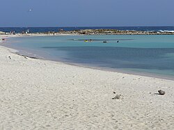
Baby Beach, is a shallow, sheltered lagoon located near Mangle Cora[1] in Seroe Colorado (formerly Roode Berg),[2] on the south-east end of the island of Aruba. It is frequented by locals and tourists. It is named Baby Beach as the water is so calm it is safe for very small children. Because of the calm water, snorkeling at this beach is safe for children and others new to snorkeling.
The beach is popular mostly due to the lack of waves and the shallow water. The Valero oil refinery is within sight of Baby Beach. However, because of the direction of local currents, Baby Beach has clean, clear water.
The water level is generally waist high on the inside but towards the inlet, it deepens significantly. Marine life in the lagoon includes barracuda, squid, parrot fish, blowfish, angelfish, eels, and many other small fish. The range of most of these animals is limited to the inlet.[citation needed]
At the beach there is a small snack stand, and chairs and umbrellas for rent. Four-wheel-drive cars, for driving around the beach, are also available to rent.[citation needed]
This is not a nude beach. Public nudity is illegal on Aruba. Topless sunbathing is tolerated on beaches in resort areas, though not on resort grounds. Topless beaches include the Renaissance Island and De Palm Island. These islands have adult beach areas where topless sunbathing and swimming are allowed.[3]
History[]
In the 1950s, the Aruba Esso Club was built as part of Lago Colony (present-day Seroe Colorado), at Baby Beach (on the west side of the lagoon).[4] The club included a restaurant, dance floor, and a baseball stadium. In the lagoon, there was a dock and small shacks (one of which is still standing). Today, there is only one large, abandoned building (with one business, a dive shop, still in operation).
See also[]
References[]
- ^ "Topographische Kaart van Aruba (1912) - Werbata-Jonckheer".
- ^ "Plan van het Eyland Aruba, opgenomen met de planchet, door Engelbertus Horst, Capitain Lieutenant en Ingenieur (1773)".
- ^ "Aruba Beaches - Photos & Descriptions". Aruba-travelguide.com. Retrieved 2016-07-04.
- ^ "Lago Colony and Lago Refinery".
External links[]
- Beaches of Aruba
- San Nicolaas