Bac Mòr
| Scottish Gaelic name | Bac Mòr |
|---|---|
| Meaning of name | large bank or obstacle |
 | |
| Location | |
 Bac Mòr Bac Mòr shown within Argyll and Bute | |
| OS grid reference | NM243387 |
| Coordinates | 56°27′N 6°28′W / 56.45°N 6.47°W |
| Physical geography | |
| Island group | Treshnish Isles |
| Area | ha |
| Highest elevation | Dutchman's Cap 86 m |
| Administration | |
| Sovereign state | United Kingdom |
| Country | Scotland |
| Council area | Argyll and Bute |
| Demographics | |
| Population | 0[1] |
| References | [2][3] |

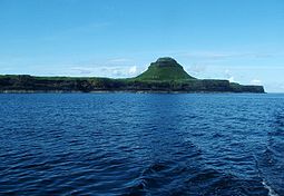
Bac Mòr is a Scottish island, one of the Treshnish Isles,[3] sometimes referred to as The Dutchman's Cap in English because of its shape.[2]
Origin of name[]
The Gaelic name has more than one possible interpretation. Although Mòr clearly means "large" (as opposed to Bac Beag, its smaller sister), the word Bac can mean either a "bank", or an "obstacle" or "hindrance".
The island's profile is one of the more distinctive amongst the Scottish Islands.
Geology[]

Bac Mòr is of ancient volcanic origin, and the peak in the middle is a former cone. The low-lying plain surrounding it is a glassy lava field.
The remains of summer sheilings have been found on the island, suggesting that it was inhabited at one time, even though it has no safe landing places.
Wildlife[]
The Treshnish Isles, which are uninhabited today, are owned by a charity, the . They have been collectively designated as a Site of Special Scientific Interest and a Special Protection Area, due to their importance for breeding seabirds. The islands are also home to a number of wildflowers.
References[]
- ^ National Records of Scotland (15 August 2013). "Appendix 2: Population and households on Scotland's Inhabited Islands" (PDF). Statistical Bulletin: 2011 Census: First Results on Population and Household Estimates for Scotland Release 1C (Part Two) (PDF) (Report). SG/2013/126. Retrieved 14 August 2020.
- ^ a b Haswell-Smith, Hamish (2004). The Scottish Islands. Edinburgh: Canongate. p. 105. ISBN 978-1-84195-454-7.
- ^ a b Ordnance Survey. "View: Sheet 44, Coll and Tiree - Ordnance Survey One-inch to the mile maps of Great Britain, Seventh Series, 1952-1961". National Library of Scotland. National Library of Scotland. Retrieved 23 January 2016.
| Wikimedia Commons has media related to Bac Mòr. |
Coordinates: 56°27′37″N 6°28′31″W / 56.46028°N 6.47528°W
Inhabited islands of the Hebrides | ||
|---|---|---|
| Inner Hebrides |  | |
| Outer Hebrides | ||
- Treshnish Isles
- Special Protection Areas in Scotland
- Sites of Special Scientific Interest in Mull, Coll and Tiree
- Special Areas of Conservation in Scotland
- Uninhabited islands of Argyll and Bute