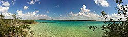
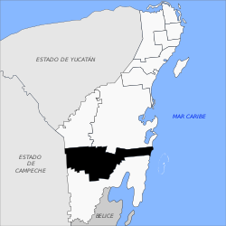
Bacalar Municipality
Bacalar | |
|---|---|
Municipality | |
 | |
 | |
 Bacalar | |
| Coordinates: 18°41′N 88°24′W / 18.683°N 88.400°WCoordinates: 18°41′N 88°24′W / 18.683°N 88.400°W | |
| Country | Mexico |
| State | Quintana Roo |
| Established | 2 February 2011 |
| Municipal seat | Bacalar |
| Government | |
| • Municipal President | José Alfredo Contreras Méndez |
| Area | |
| • Total | 7,161.1 km2 (2,764.9 sq mi) |
| Population (2010, 2019) | |
| • Total | 32,000 41,754 |
| Time zone | UTC-5 (Southeast (US Eastern)) |
| INEGI Code | 23010 |
| Website | www |

Bacalar is one of the ten municipalities of the Mexican state of Quintana Roo. The municipal seat and most populous town is the eponymous Bacalar. The municipality was formed on February 2, 2011, when it separated from the Municipality of Othón P. Blanco.
Major communities[]
The 2010 census enumerated 57 populated localities.
| Name | 2010 Census Population |
|---|---|
| Bacalar | 11,048 |
| 2,535 | |
| Maya Balam | 2,018 |
| Pedro Antonio Santos | 497 |
| Total municipality | 32,759 |

Bacalar Fort
References[]
External links[]
 Media related to Bacalar Municipality at Wikimedia Commons
- Official website
Chetumal (capital) | |||||||||||
| Municipalities (seats) |
|  | |||||||||
| Places of interest |
| ||||||||||
This article about a location in the Mexican state of Quintana Roo is a stub. You can help Wikipedia by . |
Categories:
- Municipalities of Quintana Roo
- Southern Mexico geography stubs