Badacsonytomaj
Badacsonytomaj | |
|---|---|
 | |
 Coat of arms | |
 Badacsonytomaj Location of Badacsonytomaj | |
| Coordinates: 46°48′33″N 17°30′30″E / 46.80908°N 17.50845°E | |
| Country | |
| County | Veszprém |
| Area | |
| • Total | 32.71 km2 (12.63 sq mi) |
| Population (2017) | |
| • Total | 2,070[1] |
| Time zone | UTC+1 (CET) |
| • Summer (DST) | UTC+2 (CEST) |
| Postal code | 8258 |
| Area code(s) | 87 |

Badacsonytomaj (Hungarian pronunciation: [ˈbɒdɒt͡ʃoɲtomɒj]) is a village in the Hungarian county of Veszprém with 2,341 inhabitants, as of 2011. It is located at the eastern foot of the volcanic Badacsony hill along the Lake Balaton in Hungary.
The greatest sight in the village is that of the hill itself, with its spectacular 60−70 m high basalt organs. The region around the town is well known for its high quality Hungarian wines.
The town's name was recently used in a viral promotion by Sony to promote a new feature in their PlayStation 3 Home Service. The viral campaign consisted of billboards being placed around Europe with various letters on them. Players had to piece together the letters and use the resulting word as a code.
As a municipality, it includes the smaller villages of Badacsonyörs and Badacsony as well as the town center of Badacsonytomaj.
Demography[]
Ethnic groups in the city of Badacsonytomaj
Religious groups in the village of Badacsonytomaj
The majority ethnic group in the village is Hungarian (97.34%), followed by German (2.04%).[2] The majority of residents are Roman Catholic (55.15%), 9% have no religion (6.19%). A significant number of residents' religions' are not known.[3]
References[]
- ^ Badacsonytomaj, KSH
- ^ "Componența etnică a județului Veszprém pe sate și orașe" [The ethnic composition of the county Veszprém on villages and towns]. Biroul Central de Statistică al Ungariei. Retrieved 18 February 2016.
- ^ "Componența confesională a județului Veszprém pe sate și orașe" [Composition confessional Veszprém county in villages and towns]. Biroul Central de Statistică al Ungariei. Retrieved 18 February 2016.
External links[]
- Home page (in Hungarian)
- Street map (in Hungarian)
- Laposa.hu (in Hungarian)
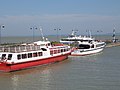
The port of Badacsonytomaj

View of Badacsonytomaj from the lake


| Wikimedia Commons has media related to Badacsonytomaj. |
Coordinates: 46°48′N 17°31′E / 46.800°N 17.517°E

| show Authority control |
|---|
This Veszprém county location article is a stub. You can help Wikipedia by . |
- Populated places in Veszprém County
- Veszprém county geography stubs