Baie-d'Hudson, Quebec
Baie-d'Hudson | |
|---|---|
Unorganized territory | |
 Baie-d'Hudson | |
| Coordinates: 58°30′N 75°00′W / 58.500°N 75.000°WCoordinates: 58°30′N 75°00′W / 58.500°N 75.000°W[1] | |
| Country | |
| Province | |
| Region | Nord-du-Québec |
| TE | Kativik |
| Constituted | unspecified |
| Government | |
| • Federal riding | Abitibi—Baie-James—Nunavik—Eeyou |
| • Prov. riding | Ungava |
| Area | |
| • Total | 156,370.40 km2 (60,374.95 sq mi) |
| • Land | 129,712.09 km2 (50,082.12 sq mi) |
| Population (2011)[3] | |
| • Total | 0 |
| • Density | 0.0/km2 (0/sq mi) |
| • Change (2006–11) | |
| • Dwellings | 0 |
| Time zone | UTC−5 (EST) |
| • Summer (DST) | UTC−4 (EDT) |

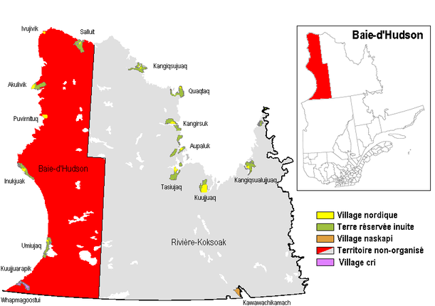
Baie-d'Hudson is a very large unorganized territory in the Kativik Regional Government territory in the Nord-du-Québec region of Quebec. It is named after Hudson Bay.
It consists of nearly the entire western part of northernmost Quebec. Bordering it to the east is the other large unorganized territory in Kativik, Rivière-Koksoak.
Its population in the Canada 2011 Census was 0; enclaved within it, however, are various northern villages (i.e., Inuit communities), a Cree reserved land, and a Cree village municipality. In the 2006 census it had a population of 16.
References[]
- ^ Reference number 149779 of the Commission de toponymie du Québec (in French)
- ^ a b Geographic code 99904 in the official Répertoire des municipalités (in French)
- ^ a b "(Code 2499904) Census Profile". 2011 census. Statistics Canada. 2012.
Categories:
- Unorganized territories in Nord-du-Québec