Baksan (river)
| Baksan | |
|---|---|
 | |
 | |
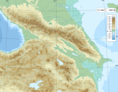
 Baksan mouth location | |
| Location | |
| Country | Kabardino-Balkaria (Russia) |
| Physical characteristics | |
| Source | Lateral Range Mount Elbrus |
| • location | Greater Caucasus |
| Mouth | Malka |
• coordinates | 43°43′59″N 44°03′48″E / 43.7331°N 44.0633°ECoordinates: 43°43′59″N 44°03′48″E / 43.7331°N 44.0633°E |
| Length | 169 km (105 mi) |
| Basin size | 6,800 km2 (2,600 sq mi) |
| Basin features | |
| Progression | Malka→ Terek→ Caspian Sea |

The Baksan, also known as Azau (Russian: Баксан, Азау) is a river in Kabardino-Balkaria in Russia. It flows east northeast and joins the Malka just before that river joins the northwest bend of the Terek. The Baksan is 169 kilometres (105 mi) long, with a drainage basin of 6,800 square kilometres (2,600 sq mi).[1]
Course[]
The Baksan originates in the Azau glacier, on the south slopes of the Elbrus. Notable tributaries are the and the Cherek.[1] On your ascent of the river, Baksan town and Tyrnyauz lie alongside it, and there is a 25 MW hydropower plant on the river.[2][3] The A158 roadway lies beside it, and bestrides it several times on the way up to Nationalpark Elbrus.
Baksan is also the site of the Baksan Underground Scintillation Telescope (BUST) of the Baksan Neutrino Observatory.[4]
Photo Gallery[]
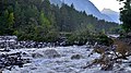
Stormy Baksan

Forest on the bank of Baksan


References[]
- ^ a b Река Баксан (Азау) in the State Water Register of Russia (Russian)
- ^ "Baksan River" (in Russian). Great Soviet Encyclopedia. Retrieved January 30, 2016.
- ^ "Baksan River Hydro" (in Russian). Baskan HPP. Retrieved January 30, 2016.
- ^ "Baksan Neutrino Observatory" (in Russian). Baskan Neutrino Observatory. Retrieved January 30, 2016.
External links[]
This Kabardino-Balkaria location article is a stub. You can help Wikipedia by . |
This article related to a river in Russia is a stub. You can help Wikipedia by . |
- Tributaries of the Terek
- Rivers of Kabardino-Balkaria
- Northern Caucasus geography stubs
- Russia river stubs