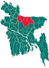
Baksiganj Upazila
Bakshiganj | |
|---|---|
Upazila | |
 Bakshiganj Location in Bangladesh | |
| Coordinates: 25°13.5′N 89°52.5′E / 25.2250°N 89.8750°ECoordinates: 25°13.5′N 89°52.5′E / 25.2250°N 89.8750°E | |
| Country | |
| Division | Mymensingh Division |
| District | Jamalpur District |
| Area | |
| • Total | 204.3 km2 (78.9 sq mi) |
| Population (2011) | |
| • Total | 218,930 |
| • Density | 1,100/km2 (2,800/sq mi) |
| Time zone | UTC+6 (BST) |
| Postal code | 2140 |
| Website | bokshiganj |
Bakshiganj (Bengali: বকশীগঞ্জ) is an upazila of Jamalpur District in the Division of Mymensingh, Bangladesh.[1]
Bakshigonj Thana was converted into an upazila in 1983. In Bakshigonj have some Haat Bazer.
Bakshigonj (Town) The area of the Bakshigonj town is 20.86 km2. It has a population of 65,568; male 50.97%, female 49.03%; population density is 2820 per km2. Literacy rate among the town people is 39.9%.
Etymology[]
Bakshiganj name of an ancient and historic towns. However, there are many differences of Bakshiganj named. The original name of the rajendraganja Bakshiganj. Still rajendraganja village records. Bakshiganj naming of a journal called smaranikara pages 44–45 published an article written by Professor Afsar Ali said. Some hundred years ago, the "paymaster" in the name of a Muslim fakir. He built up over a khanaka or dormitory. It became the residence of a hat. Bakshi, according to that person's name is the name of the market. Bakshi time evolution of the market, "bakshiganj" is the name of the converted.
History[]
Bakshiganj Thana was established in 1982 and was converted into an upazila in 1983.[1]
During the Bangladesh Liberation War, the Mukti Bahini attacked the Pakistan Army camp at Kamalpur several times.[1] Colonel Abu Taher lost his left leg on 14 November 1971, in one of those attacks.[2]
Geography[]
Bakshigonj is located at 25.2250°N 89.8750°E . It has a and total area of 204.3 km2.
Demographics[]
| Year | Pop. (000) | ±% |
|---|---|---|
| 1981 | 437 | — |
| 1991 | 157 | −64.1% |
| 2001 | 178 | +13.4% |
| 2011 | 219 | +23.0% |
| Source: Bangladesh Bureau of Statistics[3] | ||
According to the 2011 Bangladesh census, Baksiganj Upazila had 52,222 households and a population of 218,930, 13.2% of whom lived in urban areas. 12.7% of the population was under the age of 5. The literacy rate (age 7 and over) was 33.1%, compared to the national average of 51.8%.[4][5]
Administration[]
Baksiganj Upazila is divided into seven union parishads: Bagarchar, Bakshigonj, Battajore, Danua, Merurchar, Nilakhia, and Shadhurpara. The union parishads are subdivided into 25 mauzas and 199 villages.[3]
Economy[]
Economy of Bakshiganj Upazila is a major agricultural, but business and human resources are one of the key pillars of the economy of this area.
Newspapers[]
- Daily Urmi Bangla
- Daily Gonojoy
- Seba hot news
- Saptahik Bakshiganj
See also[]
- Upazilas of Bangladesh
- Districts of Bangladesh
- Divisions of Bangladesh
References[]
- ^ a b c Sayed Md Abdullah Al Mamun Chowdhury (2012), "Bakshiganj Upazila", in Sirajul Islam and Ahmed A. Jamal (ed.), Banglapedia: National Encyclopedia of Bangladesh (Second ed.), Asiatic Society of Bangladesh
- ^ Hossain, Md Anwar (2012). "Taher, Colonel Abu". In Islam, Sirajul; Jamal, Ahmed A. (eds.). Banglapedia: National Encyclopedia of Bangladesh (Second ed.). Asiatic Society of Bangladesh.
- ^ a b "District Statistics 2011: Jamalpur" (PDF). Bangladesh Bureau of Statistics. Archived from the original (PDF) on 13 November 2014. Retrieved 14 July 2014.
- ^ "Community Report: Jamalpur" (PDF). Population & Housing Census 2011. Bangladesh Bureau of Statistics. Retrieved 15 August 2018.
- ^ "Population and Housing Census 2011: Bangladesh at a Glance" (PDF). Bangladesh Bureau of Statistics. Archived from the original (PDF) on 28 July 2014. Retrieved 21 July 2014.
- Upazilas of Jamalpur District

