Ballintober North
Ballintober North
Baile an Tobair Thuaidh (Irish) | |
|---|---|
Barony | |
 Church in Whitehall, Ballintober North | |
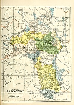 Barony map of County Roscommon, 1900; Ballintober North is coloured yellow, in the east. | |
| Sovereign state | Republic of Ireland |
| Province | Connacht |
| County | Roscommon |
| Area | |
| • Total | 124.86 km2 (48.21 sq mi) |
Ballintober North (Irish: Baile an Tobair Thuaidh[1]), also called Ballintober East, is a barony in County Roscommon, Republic of Ireland.[2]
Etymology[]
Ballintober North is named after Ballintober town, which it does not actually contain. That town is located in Castlereagh barony.
Geography[]
Ballintober North is located in the northeast of County Roscommon, bounded by the River Shannon to the east, an area with many lakes including Lough Boderg and Kilglass Lough.
History[]
This area was the ancient kingdom of , ruled by the Ó Fiannaigh (Feeney) tribe.[3] After them, the Hanleys (Ó hAinle) were the landlords of the area before losing their land in the mid-17th century.[4]
Its northern extreme was the plain of Caradh (modern Carranadoe), referred to in the topographical poem Tuilleadh feasa ar Éirinn óigh (Giolla na Naomh Ó hUidhrín, d. 1420).[5][6]
It was originally a single barony with Ballintober South; they were separated by 1841.
Wealthy landowning families in the 19th century were the Kings of Charlestown House, the Waldrons and the Goffs.[5][7]
List of settlements[]
Below is a list of settlements in Ballintober North:
References[]
- ^ "Baile an Tobair Thuaidh/Ballintober North". Logainm.ie.
- ^ "A map of Mullymucks in the barony of Ballintober South and County of Roscommon. Scale 40 perches to an inch. Names of tenants and acreage of holdings shown". catalogue.nli.ie.
- ^ "The Baronies of Ireland - Family History". sites.rootsweb.com.
- ^ "Estate Record: Hanly/Hanley". landedestates.nuigalway.ie.
- ^ a b "The Topographical Poems of John O'Dubhagain and Giolla-na-naomh O'Huidhrin: Edited in the original Irish from MSS. in the Library of the Royal Irish Academy, Dublin, with translation, notes, and introductory dissertations, by John O'Donovan". A. Thom. 2 January 1862 – via Google Books.
- ^ O'DONOVAN, JOHN (1843). THE TRIBES AND CUSTOMS OF HY-MANY, COMMONLY CALLED O'KELLY'S COUNTRY. p. 134 – via Internet Archive.
Ballintober East.
- ^ "Ashfort House". landedestates.nuigalway.ie.
Baronies of County Roscommon | ||
|---|---|---|
 | ||
| ||
Places in County Roscommon | ||
|---|---|---|
| Towns |  | |
| Villages and Townlands |
| |
| ||
- Baronies of County Roscommon