Baloué River
| Baloué River | |
|---|---|
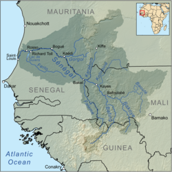 Map of the Senegal River drainage basin | |
| Location | |
| Country | Mali |
| Physical characteristics | |
| Mouth | |
• location | Bakoy River near Toukoto |
• coordinates | 13°32′58″N 9°54′35″W / 13.54944°N 9.90972°WCoordinates: 13°32′58″N 9°54′35″W / 13.54944°N 9.90972°W |
• elevation | 750 meters (2,460 ft) |
| Basin features | |
| River system | Senegal River |

The Baloué River (French: Fleuve Baloué, from Manding for "Red River") is a river in Mali in West Africa. It flows from a source west of Bamako to the Bakoy near Toukoto and forms part of the Senegal watershed.[1][2]
In Manding languages, Baloué signifies 'red river', Bakoye 'white river' and Bafing 'black river'.[1][2]
References[]
- ^ Jump up to: a b Caractéristiques physiques du fleuve Sénégal (in French), Organisation pour la mise en valeur du fleuve Sénégal, archived from the original on 16 July 2013, retrieved 2 June 2012.
- ^ Jump up to: a b Maïga, Mahamadou (1995), Le bassin du fleuve Sénégal: de la Traite négrière au développement sous-régional autocentré (in French), L'Harmattan, p. 14 footnotes 4, 5.
Categories:
- Rivers of Mali
- Senegal River
- Africa river stubs
- Mali geography stubs