Bandundu (city)
This article needs additional citations for verification. (December 2014) |
Bandundu | |
|---|---|
Provincial capital and city | |
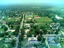 View of city center from the air, 2007 | |
 Bandundu Location in Democratic Republic of the Congo | |
| Coordinates: 3°19′S 17°22′E / 3.317°S 17.367°ECoordinates: 3°19′S 17°22′E / 3.317°S 17.367°E | |
| Country | |
| Province | Kwilu |
| City status | 1969 |
| Communes | Basoko, Disasi, Mayoyo |
| Government | |
| • Mayor | Éphrem Kinda |
| Area | |
| • Total | 222 km2 (86 sq mi) |
| Elevation | 321 m (1,053 ft) |
| Population (2012) | |
| • Total | 143,435 |
| • Density | 650/km2 (1,700/sq mi) |
| Time zone | UTC+1 (West Africa Time) |
| Climate | Aw |

Bandundu, formerly known as Banningville or Banningstad, is the capital city of Kwilu Province of the Democratic Republic of the Congo.[2]
Location[]
Bandundu is located on the east bank of the Kwango River, just north of the juncture of the Kwango and the Kwilu, and 8 kilometres (5.0 mi) south from the mouth of the Kwango on the Kasai River. It is around 260 kilometres (160 mi) from Kinshasa by air, or about 400 kilometres (250 mi) by road. In 2009, Bandundu had an estimated population of 133,080.[3]
Economy[]
Bandundu was once a significant river port, as it is the largest town on the river between Kinshasa and Kikwit. However, traffic on the Kasai and Kwango Rivers dropped dramatically as a result of the Second Congo War, and has yet to recover. Bandundu does have intermittent passenger and freight service to Kinshasa, Mushie and Kikwit. Since 2008, there is a car/truck ferry service running several times per day across the Kwango. An unpaved road, roughly 250 km long, runs from this point to the main (paved) highway between Kinshasa and Kikwit.
Bandundu is served by Bandundu Airport, with direct flights to Kinshasa.
Unlike many cities in the Congo, Bandundu has a fairly constant supply of electricity. However this has nothing to do with Inga-Shaba HVDC line, as this line has no intermediate terminals.
Climate[]
Under the Köppen climate classification, Bandundu has a tropical wet and dry climate (Aw).[4]
| hideClimate data for Bandundu | |||||||||||||
|---|---|---|---|---|---|---|---|---|---|---|---|---|---|
| Month | Jan | Feb | Mar | Apr | May | Jun | Jul | Aug | Sep | Oct | Nov | Dec | Year |
| Record high °C (°F) | 37.0 (98.6) |
35.6 (96.1) |
36.5 (97.7) |
35.5 (95.9) |
35.3 (95.5) |
34.2 (93.6) |
33.3 (91.9) |
35.4 (95.7) |
35.2 (95.4) |
34.8 (94.6) |
34.4 (93.9) |
33.9 (93.0) |
37.0 (98.6) |
| Average high °C (°F) | 30.6 (87.1) |
31.1 (88.0) |
31.4 (88.5) |
31.4 (88.5) |
31.3 (88.3) |
30.6 (87.1) |
29.5 (85.1) |
30.7 (87.3) |
31.0 (87.8) |
31.0 (87.8) |
30.5 (86.9) |
30.3 (86.5) |
30.8 (87.4) |
| Daily mean °C (°F) | 26.2 (79.2) |
26.5 (79.7) |
26.6 (79.9) |
26.7 (80.1) |
26.7 (80.1) |
25.6 (78.1) |
24.5 (76.1) |
25.5 (77.9) |
26.1 (79.0) |
26.3 (79.3) |
26.0 (78.8) |
26.1 (79.0) |
26.1 (79.0) |
| Average low °C (°F) | 21.8 (71.2) |
21.9 (71.4) |
21.8 (71.2) |
22.0 (71.6) |
22.1 (71.8) |
20.6 (69.1) |
19.5 (67.1) |
20.3 (68.5) |
21.2 (70.2) |
21.6 (70.9) |
21.5 (70.7) |
21.9 (71.4) |
21.4 (70.5) |
| Record low °C (°F) | 17.9 (64.2) |
18.2 (64.8) |
18.6 (65.5) |
18.6 (65.5) |
17.0 (62.6) |
15.8 (60.4) |
15.0 (59.0) |
15.0 (59.0) |
18.6 (65.5) |
18.5 (65.3) |
18.7 (65.7) |
17.8 (64.0) |
15.0 (59.0) |
| Average precipitation mm (inches) | 144 (5.7) |
149 (5.9) |
169 (6.7) |
171 (6.7) |
100 (3.9) |
23 (0.9) |
6 (0.2) |
22 (0.9) |
107 (4.2) |
213 (8.4) |
246 (9.7) |
192 (7.6) |
1,542 (60.7) |
| Average precipitation days (≥ 0.1 mm) | 7 | 9 | 6 | 8 | 6 | 2 | 1 | 2 | 8 | 8 | 10 | 9 | 75 |
| Source: Deutscher Wetterdienst[5] | |||||||||||||
Sister cities[]
Gallery[]

Seat of the Provincial Assembly
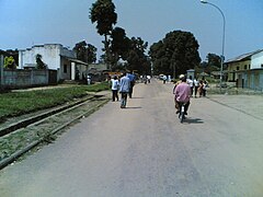
Road in the town center
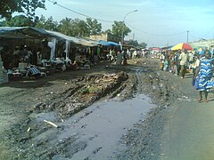
Market
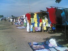
Clothing market
River Kwilu at Bandundu

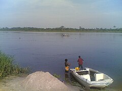
Beside the River Kwilu


See also[]
References[]
- ^ Mukiaka Say, Rolly (15 July 2019). "Bandundu : La délocalisation du marché central provoque une grève des commerçants". 7SUR7.CD (in French). Retrieved 27 August 2019.
- ^ "Loi organique nº 15/006 du 25 mars 2015 portant fixation des limites des provinces et celles de la ville de Kinshasa" (PDF). Journal officiel de la République Démocratique du Congo (in French) (Special ed.). Article 15, col=39. 56. 28 Mar 2015. Archived (PDF) from the original on 17 April 2020. Retrieved 17 April 2020.CS1 maint: location (link)
- ^ "Congo (Dem. Rep.): largest cities and towns and statistics of their population". World Gazetteer. Retrieved January 21, 2009.[dead link]
- ^ Peel, M. C.; Finlayson, B. L.; McMahon, T. A. (2007). "Updated world map of the Köppen–Geiger climate classification" (PDF). Hydrol. Earth Syst. Sci. 11 (5): 1633–1644. Bibcode:2007HESS...11.1633P. doi:10.5194/hess-11-1633-2007. ISSN 1027-5606.
- ^ "Klimatafel von Bandundu, Region Bandundu / Dem. Rep. Kongo (Zaire)" (PDF). Baseline climate means (1961-1990) from stations all over the world (in German). Deutscher Wetterdienst. Retrieved 1 April 2016.
| show Capitals of the provinces of the Democratic Republic of the Congo |
|---|
| show Authority control |
|---|
This Democratic Republic of the Congo location article is a stub. You can help Wikipedia by . |
- Bandundu (city)
- Populated places in Kwilu Province
- Democratic Republic of the Congo geography stubs