Baneheide
Baneheide | |
|---|---|
Buurtschap | |
 | |
 Baneheide Location of Baneheide in the Netherlands | |
| Coordinates: 50°49′5″N 5°58′28″E / 50.81806°N 5.97444°ECoordinates: 50°49′5″N 5°58′28″E / 50.81806°N 5.97444°E | |
| Country | Netherlands |
| Province | Limburg (Netherlands) |
| Municipality | Simpelveld |
| Area | |
| • Total | 0.39 km2 (0.15 sq mi) |
| Population (2007) | 150 |


Baneheide (50°49′N 5°59′E / 50.817°N 5.983°E) is a town in the Dutch province of Limburg. It is a part of the municipality of Simpelveld, and lies about 9 km southwest of Kerkrade.
In 2001, Baneheide had 65 inhabitants. The built-up area of the town was 0.03 km² and contained 27 residences.[1]
National monuments[]
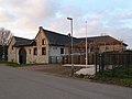
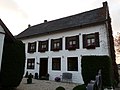
Baneheide has four farms that have been designated national monuments.


References[]
- ^ Statistics Netherlands (CBS), Bevolkingskernen in Nederland 2001 "Archived copy". Archived from the original on 2006-03-19. Retrieved 2007-01-24.
{{cite web}}: CS1 maint: archived copy as title (link). Statistics are for the continuous built-up area. - ^ Rijksmonument nr 33595
- ^ Rijksmonument nr 33596
- ^ Rijksmonument nr 33618
- ^ Rijksmonument nr 33617
This Dutch Limburg location article is a stub. You can help Wikipedia by . |
Categories:
- Populated places in Limburg (Netherlands)
- Simpelveld
- Limburg (Netherlands) geography stubs