Bangor Erris
This article needs additional citations for verification. (September 2014) |
Bangor Erris
Beannchar | |
|---|---|
Town | |
 Bangor Erris Location in Ireland | |
| Coordinates: 54°08′35″N 9°44′25″W / 54.1431°N 9.7403°WCoordinates: 54°08′35″N 9°44′25″W / 54.1431°N 9.7403°W | |
| Country | Ireland |
| Province | Connacht |
| County | County Mayo |
| Elevation | 96 m (315 ft) |
| Population (2016)[1] | 306 |
| Time zone | UTC+0 (WET) |
| • Summer (DST) | UTC-1 (IST (WEST)) |
| Irish Grid Reference | F863229 |

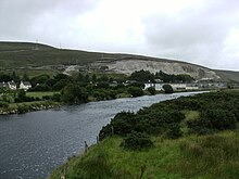
Bangor Erris (Irish: Beannchar) is a town in Kiltane parish in Erris, County Mayo, Ireland with a population of over 300.[1] It is on the banks of the Owenmore River and is a "gateway" to the Erris Peninsula linking Belmullet with Ballina and Westport. It is located at the foot of the "Bangor Trail" a 22-mile mountain pass across the Nephin Beg (Irish: Néifinn Bheag) Mountain Range to Newport. Approximately 2 km away is Carrowmore Lake, (Irish: Loch na Ceathrú Móire) Bangor is a centre for wild atlantic salmon and sea trout fishing. Bangor Erris is located in the Parish of Kiltane. Due west from Bangor are the towns of Belmullet, Geesala, Mulranny, Westport and Doolough
History[]

The original name for Bangor was Doire Choinadaigh (Kennedy's Wood), a name found on maps from 1724 - 1829. the place was also called 'Coineadach' by John O'Donovan in the Ordnance Survey Name Books of 1838. In 1802 when James McPartlan (Statistical Survey p. 159) surveyed the area, he called the village 'Cahal' and noted that there were regular fairs held there at that time. Locally the village was known as 'Aonach Cathail' because a wealthy buyer of that name was a regular at the fair days. The name 'Bangor' was given to the village by Major Denis Bingham who established the town of Bangor Erris.
The reason Bangor was chosen as a site for Bingham's town was because it was situated at the crossroads of two old roads which were in use from about the middle of the 18th century. One road led from Carne (Mullet peninsula) to Castlebar and the other went from Inver (Kilcommon) to Newport. Both roads were repaired by order of the County Assizes in 1793. The crossroads was well sheltered from the worst of the prevailing winds and its situation on the banks of the Owenmore River also made it a suitable site.
Major Bingham introduced the Revenue Police to stamp out the illicit distillation of drink, in reality it was to get personal protection for himself in his house Bingham Lodge on the western edge of the town. A post office was established in the town in 1842.[2]
The dates back to the mid 19th Century.
The Townagh flood
In December 1818, four lakes just outside Bangor Erris burst their banks after heavy rains, unleashing a torrent of water that killed 17 people. The majority of the victims were from the O'Hara family. Three soldiers from the 92nd Highlanders were also killed. The soldiers were on revenue duty and were lodging with the O'Hara family. All three soldiers were veterans of Waterloo. At the same times, two other soldiers were killed when they got lost in the bog during the storm.[3]
Irish War of Independence
In January 1921, a local man - Michael McAndrew (aged 27) was stabbed in the neck by a soldier. McAndrew was attempting to take the soldier's rifle when he received the wound. He was taken to Belmullet Hospital where he survived the injury.[4]
Transport[]
Bus Éireann route 446 links Bangor Erris with Bellacorick, Crossmolina and Ballina. In the reverse direction it links to Belmullet and the Mullet Peninsula. There are now 4 services a day in each direction, including Sundays. On Friday evenings an extra journey operates from Ballina.[5] Onward rail and bus connections are available at Ballina.
Facilities[]
There are three public houses in Bangor; the Talk Of The Town, the Kiltane Tavern and the West End Bar. There is one supermarket/grocery shop in Bangor, Carrabine's. There is a bookmakers and a hardware store also. Bangor National School which is attended by the children of Bangor and other neighboring villages such as Tawnagh and Bellacorick. Bangor Hibs have an all weather astroturf pitch which is used for 5 a side football.[citation needed] Across from the national school is the Catholic church.
Sport[]
The GAA Club in Kiltane is Kiltane GFC. Kiltane were founded in 1964 and wear blue and gold jerseys. They won the Junior and Intermediate Championships in 1972 and 1973 respectively.
The soccer club in Bangor Erris is named Bangor Hibernians F.C. They play at Ballybeg Park. Founded in 1995 the club plays in the Premier division of the Mayo Association League.[citation needed] The club's colours are blue and black vertical stripes. The club crest denotes the "Big Bridge" in Bangor which carries traffic over the Owenmore River and is situated close to the club's home ground.[citation needed] The club's first major Junior Cup Final victory came against Partry Athletic in the Tonra Cup in 2006.[citation needed] In 2011, the club claimed the Tuohy Cup.[citation needed] Also in 2011, the team recorded a first ever League title (PREMIER B) following a 2-1 home win over local rivals Crossmolina.[citation needed] Bangor Hibs were named Mayo League Club of the Year in 2011.[citation needed] Bangor Hibs added a second League title in 2015 when they also won the Premier Division B title. As of 2018 the club are in the Mayo League Premier Division.[citation needed]
Notable people[]
- Johnny Carey (Gaelic footballer)
- John McAndrew (Gaelic footballer) - A member of the 1950 and 1951 Mayo teams that won the All-Ireland. [6]
- Eileen Lynn Kato - A renowned academic and translator of Japanese poetry and theater. In 1991, she was appointed as Gakari (advisor) to the Japanese emperor.
- Rosaleen Gallagher (Paralympian) In the 1968 summer Olympics Rosaleen Gallagher won a medal in four different sports; archery, athletics, swimming and table tennis.(1) She went on to compete in many other games. Rosaleen Gallagher is Ireland's most successful Paralympian in individual events. She was awarded the freedom of the city of Toronto, Canada and the Mayo Association of New York dedicated March 15th as Rosaleen Gallagher day.
Folklore[]
The area around Bangor Erris is rich in local folklore. The legend of the Ulster Cycle took place not far from Bangor Erris at the fort at Rathmorgan beside Carrowmore Lake. Known as Táin Bó Flidhais it tells the story of a cattle raid around the 1st century AD.
There is a folktale that the road between Bangor Erris and Ballycroy is haunted by magical creatures. A phantom dog sometimes appears, as does a white cow, whose appearance is regarded as a warning of death. Several of the local lakes are associated with folk tales of 'water horses", which sometimes come onto the land and try to get people to mount them, and subsequently take them off into the water.[7]
See also[]
- List of towns and villages in Ireland
References[]
- Noone, Fr. Sean. Where the Sun Sets (1991) Kildare.
- ^ Jump up to: a b "Census 2016 Sapmap Area: Settlements Bangor Erris". Central Statistics Office. Retrieved 23 March 2018.
- ^ "Varieties". Kerry Examiner. October 1842.
- ^ "Eruption of four lakes in the county of Mayo". Westmorland Gazette. 26 December 1818.
- ^ "Dublin Castle Reports". Freemans Journal. 4 January 1921.
- ^ "Archived copy" (PDF). Archived from the original (PDF) on 17 May 2012. Retrieved 6 June 2012.CS1 maint: archived copy as title (link)
- ^ "Player for Mayo team that won two finals in early 1950s". Irish Times. 2 February 2013.
- ^ Browne, Charles (1837). The Ethnography of BallyCroy, County Mayo, Proceedings of the Royal Irish Academy. Dublin: Royal Irish Academy. pp. 105.

- Towns and villages in County Mayo
- Erris