Banjska Monastery
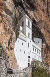
 View of the Banjska monastery church | |
| Monastery information | |
|---|---|
| Full name | Манастир Светог архиђакона Стефана - Бањска |
| Order | Serbian Orthodox |
| Established | 1317 (reestablished in 2004) |
| Disestablished | 16th century |
| Dedicated to | Saint Archdeacon Stephen |
| Diocese | Eparchy of Raška and Prizren |
| People | |
| Founder(s) | King Stefan Uroš II Milutin |
| Architecture | |
| Heritage designation | Cultural monument of Exceptional Importance |
| Designated date | 26 August 1947[1] |
| Site | |
| Location | Hill near Zvečan, Kosovo[a] |
| Public access | Limited |
The Banjska Monastery (Serbian: Манастир Бањска, romanized: Manastir Banjska, ![]() listen (help·info); Albanian: Manastiri i Banjskës) is a Serbian Orthodox monastery in the Banjska village near Zvečan, Kosovo.[a]
listen (help·info); Albanian: Manastiri i Banjskës) is a Serbian Orthodox monastery in the Banjska village near Zvečan, Kosovo.[a]
History[]
This section does not cite any sources. (November 2016) |
The monastery, along with the Church of St Stephen, was built between 1313 and 1317, founded by Serbian King Stefan Milutin, one of the most powerful rulers of his time and of the Nemanjić dynasty. Milutin built the church as his mausoleum (burial place), and it is where he was first laid to rest. However, following the Battle of Kosovo (1389), his body was moved to Trepča and then in 1460 to Sofia (Bulgaria), where it lies to this day.
The monastery shared the fate of its founder. The monumental building with its church, library, monks' quarters and "imperial palace" began to fall into disrepair very early. At the beginning of the 15th century, a fire destroyed the library and in the second half of the same century, the monastery was probably abandoned. , a traveller, mentioned that the monastery was razed to the ground in the 16th century on the orders of the Ottoman Sultan, as Christians who had fled Ottoman tyranny were gathering in it.
St Stephen's, almost totally destroyed, was turned into a mosque in the 19th century and served as such until World War I. The first conservation activity was carried out in 1939 and again in 1990 when the church was partly rebuilt. The monastery is one of the few for which the founding charter has been preserved; it was granted a large estate at its founding, of 75 villages and 8 pastures. As the complex was built as the final resting place of a king, the bishopric was "upgraded" to a stavropegial monastery - roughly translated, an Imperial monastery, fourth by rank in the state (after Studenica, Mileševa and Sopoćani).
The building works were led by Archbishop Danilo II,[2] at that time a prior, later Serbian Archbishop, who was a close confidant to the king. According to medieval sources, as well as an oral tradition, Banjska was one of the most beautiful Serbian monasteries, built in the Raška architectural style, which was used for all royal mausoleums, from Stefan Nemanja's Studenica monastery to Emperor Dušan's Monastery of the Holy Archangels. The monastery was declared a Monument of Culture of Exceptional Importance in 1990, and is protected by the Republic of Serbia.
See also[]
- List of Serbian Orthodox monasteries
Notes[]
| a. | ^ Kosovo is the subject of a territorial dispute between the Republic of Kosovo and the Republic of Serbia. The Republic of Kosovo unilaterally declared independence on 17 February 2008. Serbia continues to claim it as part of its own sovereign territory. The two governments began to normalise relations in 2013, as part of the 2013 Brussels Agreement. Kosovo is currently recognized as an independent state by 97 out of the 193 United Nations member states. In total, 113 UN member states are said to have recognized Kosovo at some point, of which 15 later withdrew their recognition. |
Further reading[]
- Novaković, S. (1892) Manastir Banjska - zadužbina Kralja Milutina u srpskoj istoriji. Glas Srpske kraljevske akademije, Beograd, 32, 35-41
- Todić, Branislav (1999). Serbian Medieval Painting: The Age of King Milutin. Belgrade: Draganić.
References[]
- ^ "Манастир Бањска". Central Register of Immovable cultural property. Institute for the Protection of Cultural Monuments of Serbia. Retrieved 1 August 2020.
- ^ [1][dead link]
External links[]
| Wikimedia Commons has media related to Banjska Monastery. |
| show |
|---|

| show Serbian Orthodox Church |
|---|

Coordinates: 42°58′17″N 20°46′57″E / 42.97139°N 20.78250°E

| show Authority control |
|---|
- Cultural Monuments of Exceptional Importance (Serbia)
- Nemanjić dynasty endowments
- Serbian Orthodox monasteries in Kosovo
- Monuments and memorials in Kosovo
- Religious organizations established in the 1310s
- Persecution of Serbs
- 14th-century Serbian Orthodox church buildings
- District of Mitrovica
- Rebuilt buildings and structures
- Religious buildings and structures converted into mosques
- Medieval Serbian sites in Kosovo
- Christian monasteries established in the 14th century
- Medieval Serbian Orthodox monasteries