Banka, Piešťany District
Banka | |
|---|---|
Village | |
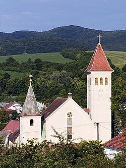 Church of St. Martin in Banka | |
 Banka Location of Banka in the Trnava Region | |
| Coordinates: 48°35′00″N 17°51′00″E / 48.58333°N 17.85000°ECoordinates: 48°35′00″N 17°51′00″E / 48.58333°N 17.85000°E | |
| Country | Slovakia |
| Region | Trnava |
| District | Piešťany |
| First mentioned | 1241 |
| Government | |
| • Mayor | Tatiana Julinyova |
| Area | |
| • Total | 8.58 km2 (3.31 sq mi) |
| Elevation | 175 m (574 ft) |
| Population (2007-12-31) | |
| • Total | 2,174 |
| • Density | 250/km2 (660/sq mi) |
| Postal code | 921 01 |
| Area code(s) | +421-33 |
| Car plate | PN |


Banka is a village and municipality in Piešťany District in the Trnava Region of western Slovakia, near the Váh river.
History[]
The site was inhabited for thousands of years, with the archaeological site dating inhabitation from the Paleolithic age. In historical records the village was first mentioned in 1241. From 1973-1996 it was part of the town of Piešťany.
Geography[]
The municipality lies at an altitude of 210 metres and covers an area of 8.583 km². It has a population of about 2174 people.
Genealogical resources[]
The records for genealogical research are available at the state archive "Statny Archiv in Bratislava, Slovakia"
- Roman Catholic church records (births/marriages/deaths): 1783-1905 (parish B)
See also[]
External links[]
| Wikimedia Commons has media related to Banka. |
- https://web.archive.org/web/20100202015957/http://www.statistics.sk/mosmis/eng/run.html
- Surnames of living people in Banka
Municipalities of Piešťany District | ||
|---|---|---|
This Trnava Region geography article is a stub. You can help Wikipedia by . |
Categories:
- Villages and municipalities in Piešťany District
- Trnava Region geography stubs