Barima River
| Barima River | |
|---|---|
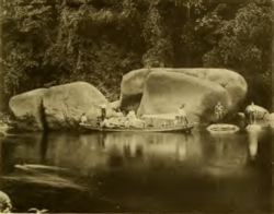
 Arawatta Rock in the Barima River | |
 Location of mouth | |
| Location | |
| Country | Guyana, Venezuela |
| Physical characteristics | |
| Mouth | |
• coordinates | 8°35′N 60°25′W / 8.583°N 60.417°WCoordinates: 8°35′N 60°25′W / 8.583°N 60.417°W |
The Barima River is a tributary of the Orinoco River, entering 6 kilometres (4 mi) from the Atlantic Ocean. It originates from the Imataka Mountains in Guyana,[1] flowing for approximately 340 kilometres (210 mi) before entering Venezuela about 80 kilometres (50 mi) from its mouth.
Features[]
Early recorded explorations of the Barima were made by Robert Hermann Schomburgk, which was mapped as far as the tributary Rocky River.[2]
The head of the Barima rises in a steep gorge of the Imataka mountains, 950 ft. above sea level.[2] Near the Duquari Creek, the Arawatta Rock, a distinct large granite rock, is located.[1]
Settlements[]
Mabaruma,[3] Koriabo,[4] and Morawhanna are Barima-Waini Region communities on the Barima River.
See also[]
References[]
- ^ a b Harrison, John Burchmore; Fowler, Frank; Anderson, Charles Wilgress (1908). The geology of the goldfields of British Guiana. Smithsonian Libraries. [London] Dulau & Co. pp. 107, 109.
- ^ a b Dixon, George G. (1895). "Four Months of Travel in British Guiana". The Geographical Journal. 5 (4): 343–344. doi:10.2307/1774100. ISSN 0016-7398.
- ^ "Gov't re-establishes Mabaruma-Morawhanna road link". Guyana Chronicle. Retrieved 31 August 2020.
- ^ "SPANISH RAIDS ON DUTCH TERRITORY (1758-1768)". Guyana.org. Retrieved 31 August 2020.
| Wikimedia Commons has media related to Barima River. |
Categories:
- Rivers of Guyana
- Rivers of Venezuela
- Orinoco basin
- International rivers of South America
- South America river stubs
- Guyana geography stubs
- Venezuela river stubs
