Barkly Highway
Barkly Highway[1] –Queensland | |
|---|---|
 | |
| Barkly Highway in Queensland | |
| General information | |
| Type | Highway |
| Length | 754 km (469 mi) |
| Route number(s) |
|
| Former route number | |
| Major junctions | |
| West end | |
| |
| East end | |
| Location(s) | |
| Major settlements | Camooweal, Mount Isa |
| Highway system | |
The Barkly Highway is a national highway of both Queensland and the Northern Territory in Australia.[2] It is the only sealed road between Queensland and the Northern Territory.[3][4]
Description[]

The highway runs between Cloncurry and the junction with the Stuart Highway north of Tennant Creek, known as the "Threeways". The entire highway is part of the National Highway system: in the Northern Territory it is assigned National Route 66; the Queensland portion is designated as National Route A2.

An upgrade of the Queensland section of the highway between Mount Isa and Camooweal was completed in 2008 and despite floods of 2009, 2010 and 2011, the Queensland sections of road were in good condition (as of 2015).
The Northern Territory section has a speed limit of 130 kilometres per hour (81 mph) along most of its length.[5]
It is the main transport route between Queensland and the Northern Territory, consequently many road trains use it.
Georgina River Bridge[]

Given the economic importance of transport on this route, a longstanding problem was the flooding of the Georgina River immediately west of Camooweal in Queensland. As the water levels in the Georgina River vary enornmously from being completely dry to flooding, the Barkly Highway bridge over the Georgina River was often unusable for many days due to flooding, with road trains and other heavy vehicles having to wait weeks before it was safe to cross. To alleviate these problems, the Georgina River Bridge was officially opened on 20 December 2002 by Senator Ron Boswell and Steve Breadhauer, Minister for Transport in the Queensland Government. It replaced the previous bridge which was approximately 50 metres (160 ft) south, and is both higher and longer so traffic on the highway can continue to cross during floods. The bridge is 417 metres (1,368 ft) long and is accompanied by a 5.6-kilometre (3.5 mi) highway deviation west from Camooweal. The bridge uses an unusual arch design to avoid placing pylons into the river bed which is culturally significant to the local Dugalunji people, who call the new bridge Ilaga Thuwani meaning The Camping Ground of the Rainbow Serpent.[4][6][7][8]
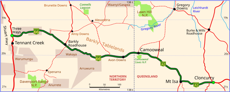
Barkly Highway in Queensland and the Northern Territory (green and black)


List of towns along the Barkly Highway[]
Major intersections[]
| State | LGA | Location | km[9] | mi | Destinations | Notes |
|---|---|---|---|---|---|---|
| Northern Territory | Barkly | Warumungu | 0 | 0.0 | south – Alice Springs | Barkly Highway western terminus - continues east as National Highway 66 |
| Tablelands | 186 | 116 | ||||
| Northern Territory – Queensland state border | 433 | 269 | Northern Territory – Queensland state border | Barkly Highway continues east as National Highway A2 | ||
| Queensland | Georgina River | 445 | 277 | Georgina River Bridge (Ilaga Thuwani Bridge) | ||
| Mount Isa | Camooweal | 446 | 277 | Camooweal Urandangie Road - south – Urandangi | ||
| 448 | 278 | |||||
| Mount Isa | 635 | 395 | Barkly Highway continues east as National Highway A2 duplexed with National Route 83. Western concurrency terminus with National Route 83. | |||
| Leichhardt River | 635 | 395 | Sir James Foots Bridge | |||
| Cloncurry | Cloncurry | 754 | 469 | Eastern end of Barkly Highway. Eastern concurrency terminus with National Route 83. | ||
1.000 mi = 1.609 km; 1.000 km = 0.621 mi
| ||||||
See also[]
![]() Australian Roads portal
Australian Roads portal
- Highways in Australia
- List of highways in the Northern Territory
- List of highways in Queensland
- List of highways numbered 66
References[]
- ^ Driver, A.R. (1 May 1947). "THE NORTHERN TERRITORY OF AUSTRALIA, Nomenclature (Public Places) Ordinance 1945". Commonwealth of Australia Gazette. No. 79. Australia. p. 1233. Retrieved 22 May 2019 – via National Library of Australia.
Barkly Highway.—The main road stretching from the Northern Territory Queensland Border in the vicinity of Camooweal in a westerly direction to join the Stuart Highway at a point about 15 miles north of Tennant Creek.
- ^ Hema, Maps (2005). Australia’s Great Desert Tracks NE Sheet (Map). Eight Mile Plains Queensland: Hema Maps. ISBN 978-1865005461.
- ^ "Road trip driving routes, car & 4WD | Northern Territory, Australia". Tourism Northern Territory. Archived from the original on 21 December 2020. Retrieved 21 December 2020.
- ^ a b Boswell, Ron (9 April 2001). "Expressions of Interest sought for Georgina River Bridge construction". Australian Parliament. Archived from the original on 21 December 2020. Retrieved 21 December 2020.
- ^ "Northern Territory Information". Gondwananet.
- ^ Boswell, Ron (13 June 2002). "Georgina River Bridge underway". Australian Parliament. Archived from the original on 21 December 2020. Retrieved 21 December 2020.
- ^ TheBeanTeam (22 August 2012). "Ilaga Thuwani Bridge - 2002 - Camooweal, Queensland, Australia - Bridge Date Stones and Plaques on Waymarking.com". www.waymarking.com. Archived from the original on 21 December 2020. Retrieved 21 December 2020.
- ^ Memmott, Paul. "On Generating Culturally Sustainable Enterprises and Demand-Responsive Services in Remote Aboriginal Settings: A case study from north-west Queensland". Indigenous Participation in Australian Economies II. Australian National University. Archived from the original on 21 December 2020. Retrieved 21 December 2020.
- ^ Google (24 December 2017). "Barkly Highway" (Map). Google Maps. Google. Retrieved 24 December 2017.
External links[]
![]() Media related to Barkly Highway at Wikimedia Commons
Media related to Barkly Highway at Wikimedia Commons
Road infrastructure in Northern Territory | ||
|---|---|---|
| National highways | ||
| Highways | ||
| Major urban roads | ||
| Outback tracks and numbered state routes | ||
- Highways in the Northern Territory
- Highways in Queensland
- North West Queensland