Barum, Lüneburg
Barum | |
|---|---|
 Coat of arms | |
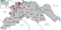
show Location of Barum within Lüneburg district | |
 Barum | |
| Coordinates: 53°21′7″N 10°24′22″E / 53.35194°N 10.40611°ECoordinates: 53°21′7″N 10°24′22″E / 53.35194°N 10.40611°E | |
| Country | Germany |
| State | Lower Saxony |
| District | Lüneburg |
| Municipal assoc. | Bardowick |
| Subdivisions | 3 |
| Government | |
| • Mayor | Werner Meyn (CDU) |
| Area | |
| • Total | 9.8 km2 (3.8 sq mi) |
| Elevation | 4 m (13 ft) |
| Population (2020-12-31)[1] | |
| • Total | 2,079 |
| • Density | 210/km2 (550/sq mi) |
| Time zone | UTC+01:00 (CET) |
| • Summer (DST) | UTC+02:00 (CEST) |
| Postal codes | 21357 |
| Dialling codes | 04133 |
| Vehicle registration | LG |
| Website | Homepage der Samtgemeinde |


St. Dionysius-Church in St. Dionys
Barum is a municipality in the district of Lüneburg, in Lower Saxony, Germany. Barum has an area of 9.8 km² and a population of 1,844 (as of December 31, 2007). Barum is subdivided into the parts Barum, Horburg and St. Dionys. Barum is crossed by the river Neetze.
References[]
| show Towns and municipalities in Lüneburg (district) |
|---|
| Authority control |
|---|
This Lüneburg district location article is a stub. You can help Wikipedia by . |
Categories:
- Municipalities in Lower Saxony
- Lüneburg (district)
- Lüneburg region geography stubs