Bay Springs Lake
| Bay Springs Lake | |
|---|---|
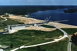 Jamie Whitten Lock and Dam | |
 Bay Springs Lake | |
| Location | Tishomingo / Prentiss counties, Mississippi |
| Coordinates | 34°34′16″N 88°18′58″W / 34.5710°N 88.3160°WCoordinates: 34°34′16″N 88°18′58″W / 34.5710°N 88.3160°W |
| Type | reservoir |
| Primary inflows | Tennessee-Tombigbee Waterway |
| Primary outflows | Tennessee-Tombigbee Waterway |
| Basin countries | United States |
| Max. length | 9 mi (14 km) |


Bay Springs Lake is a reservoir on the Tennessee-Tombigbee Waterway in the U.S. state of Mississippi. It is impounded by the Jamie Whitten Lock and Dam. The lake is approximately nine miles long, between waterway mile markers 412 at the dam, and 421 near the entrance to the divide cut.
External links[]
- "map of Bay Springs Lake" (PDF). Archived from the original (PDF) on 2006-09-22. (389 KiB) from USACE.
This Prentiss County, Mississippi state location article is a stub. You can help Wikipedia by . |
This Tishomingo County, Mississippi state location article is a stub. You can help Wikipedia by . |
Categories:
- Protected areas of Prentiss County, Mississippi
- Reservoirs in Mississippi
- Protected areas of Tishomingo County, Mississippi
- Bodies of water of Prentiss County, Mississippi
- Bodies of water of Tishomingo County, Mississippi
- Mississippi Hills region geography stubs