Bay of Vlorë
| Bay of Vlorë | |
|---|---|
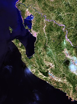 Map of the Bay of Vlorë | |
 Bay of Vlorë | |
| Location | Southern Europe |
| Coordinates | 40°27′0″N 19°24′0″E / 40.45000°N 19.40000°ECoordinates: 40°27′0″N 19°24′0″E / 40.45000°N 19.40000°E |
| Ocean/sea sources | Adriatic Sea, Ionian Sea, Mediterranean Sea |
| Basin countries | Albania |
| Max. length | 10 km (6.2 mi) |
| Surface area | 250 km2 (97 sq mi) |
| Average depth | 25 m (82 ft) |
| Settlements | Vlorë |

The Bay of Vlorë (Albanian: Gjiri i Vlorës — Albanian pronunciation: [ˈɟiːɾi i ˈvlɔːɾəs]) is a large bay of the Adriatic Sea situated along the Albanian Adriatic Sea Coast on the Mediterranean Sea in Southern Europe. It opens to the sea in the northwest and is largely surrounded by the lagoon of Narta in the north, the city of Vlorë in the northeast, the mountains of the Ceraunians in the east and southeast, and the peninsula of Karaburun in the southwest and west.
Biodiversity[]
The bay is categorized as an Important Bird and Plant Area by virtue of it provides excellent habitats for a vast array of bird and plant species.[1][2]
Geography[]
The Karaburun Peninsula, which stretches at the meetingpoint of the Adriatic and Ionian Sea, encompasses the western shoreline of the bay that is highly hilly and irregular in structure and is home to the Karaburun-Sazan Marine Park.[3]
History[]
In antiquity (pre-400 BCE) the northernmost limit of Chaonian rule was located at the northern end of the bay of Vlorë.[4] The region of Chaonia usually stretched up to western edge of the bay corresponding to the Akrokeraunian peninsula.[5] In classical antiquity Greek speakers were found in the coastal areas of the bay and as north as the mouth of Aoos.[6] Illyrians were found in the hinterland of the Bay of Vlorë.[7]
In Roman times, the region was a significant place and was the scene, for example, of some of Caesar's battles. It has been suggested that Julius Caesar landed inside the Bay of Vlorë from Brundusium across the Adriatic, in order to carry on the Civil War against Pompey in Illyricum and the oncoming Battle of Dyrrhachium on 10 July 48 BC.[8]
In one account, 18 ships full of merchandise have sunk in the Bay. Studying the Bay of Vlorë, it has been one of the main projects of the navigation department of the University of Vlora in the last few years.[9] The southwestern end of the Bay, at the naval base of Pashaliman, has been used as a harbor since antiquity. The city was called Oricum. During the Cold War, it was temporarily a Soviet naval base, the only one in the Mediterranean sea.[citation needed]
|


See also[]
References[]
- ^ BirdLife International. "Vlora Bay, Karaburun Peninsula and Cika mountain". datazone.birdlife.org. p. 1.
- ^ IUCN, World Wide Fund for Nature, Plantlife. "Important Plant Areas of the south and east Mediterranean region" (PDF). portals.iucn.org. p. 75.CS1 maint: multiple names: authors list (link)
- ^ "Management Plan for National Marine Park Karaburun-Sazan" (PDF). mcpa.iwlearn.org. p. 10.
- ^ Hammond 1997, p. 55: "Chaonian power thus ran from the northern end of the Gulf of Aulon (adjacent to Apollonia) to the southern end of the plain by Konispolis"
- ^ Bejko et al. 2015, p. 4: "The tumulus is located somewhat to the north and east of ancient Chaonia—usually located between the Thyamis River in Greek Epirus (the mod-ern Kalamas) and the Akrokeraunian headland, the modern Karaburun peninsula that defines the western edge of the bay of Vlorë, the ancient Aulon, in Albania (...)—and to the north and west of Atintania (...)."
- ^ Hatzopoulos 1997, p. 145: "The above review suggests that the boundaries of Hellenism in Epirus during Classical Antiquity lay in the valley of the Aoos. Is it purely change that at the present day, the northernmost Greek-speaking villages of Arta and Svernitsa in the Gulf of Aulon - isolated relics of the ancient Horikioi and Balaiitai?
- ^ De Simone 2017, p. 1867: "According to Hammond and Wilkes (...) the Illyrians were “a large group of related Indo-European tribes, who occupied in classical times the western side of the Balkan range from the head of the Adriatic Sea to the hinterland of the Gulf of Valona and extended northwards as far as the eastern Alps and the Danube and eastwards into some districts beyond the Balkan range.”"
- ^ Longhurst 2016, p. 132: "The most significant problem is the identification of Caesar’s landing place for his army with Palaeste, when it can be shown that he probably landed inside the Gulf of Valona." 134: "Pompey’s army was dispersed in winter quarters leaving his main supply base of Dyrrachium (Durazzo or Durrës) potentially vulnerable to a surprise attack. Caesar planned to land his army on the coast of Illyricum (Albania), as near as he could to Dyrrachium, march on the city and seize Pompey’s supplies."
- ^ "UNIVERSITETI I VLORES 'Ismail Qemali' – Virtus Scientia Veritas". Univlora.edu.al. Archived from the original (PDF) on 2014-02-03. Retrieved 2013-04-22.
Bibliography[]
- Bejko, Lorenc; Morris, Sarah; Papadopoulos, John; Schepartz, Lynne (2015). The Excavation of the Prehistoric Burial Tumulus at Lofkend, Albania. ISD LLC. ISBN 1938770528.
- De Simone, Carlo (2017). "Illyrian". In Klein, Jared; Joseph, Brian; Fritz, Matthias (eds.). Handbook of Comparative and Historical Indo-European Linguistics. 3. Walter de Gruyter. pp. 1867–1872. ISBN 978-3-11-054243-1.
- Hammond, N.G.L. (1997). "Hammond The Tribal Systems of Epirus and Neighbouring Areas down to 400 B.C.". Epirus, 4000 Years of Greek History and Civilization.
- Hatzopoulos, M. B. (1997). "The Borders of Hellenism in Epirus during Antiquity". In M. V. Sakellariou (ed.). Ηπειρος: 4000 χρόνια ελληνικής ιστορίας και πολιτισμού. Ekdotike Athenon. ISBN 9789602133712.
- Longhurst, Ian (2016). Caesar's Crossing of the Adriatic Countered by a Winter Blockade During the Roman Civil War. The Mariner's Mirror. 102. Routledge. pp. 132–152. doi:10.1080/00253359.2015.1054681.
| Authority control |
|
|---|
This article about a specific location in Vlorë County, Albania, is a stub. You can help Wikipedia by . |
- Bays of Albania
- Bays of the Mediterranean
- Bodies of water of Albania
- Important Bird Areas of Albania
- Albanian Adriatic Sea Coast
- Vlorë County geography stubs