Baynard Boulevard Historic District
Baynard Boulevard Historic District | |
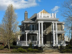 House in the Baynard Boulevard Historic District, March 2010 | |
 | |
| Location | Baynard Blvd. between 18th St. and Concord Ave., Wilmington, Delaware |
|---|---|
| Coordinates | 39°45′29″N 75°32′40″W / 39.758143°N 75.544323°WCoordinates: 39°45′29″N 75°32′40″W / 39.758143°N 75.544323°W |
| Area | 24 acres (9.7 ha) |
| Built | 1893 |
| Architectural style | Colonial Revival, Tudor Revival, Queen Anne |
| NRHP reference No. | 79000631[1] |
| Added to NRHP | July 26, 1979 |


The Baynard Boulevard Historic District is a national historic district located at Wilmington, New Castle County, Delaware. It encompasses 77 contributing buildings with examples of Colonial Revival, Tudor Revival, and Queen Anne architecture. The area developed after being laid out in 1893, and is a prime example of a turn-of-the-20th-century American suburb, or "streetcar suburb." The dwellings date between 1895 and 1930. The district is predominantly residential. Also located in the district is the McCabe United Methodist Church, Beth Shalom Synagogue, Hanover Presbyterian Church, and No. 30 School.[2]
It was added to the National Register of Historic Places in 1979.[1]

1908 Baynard Blvd.
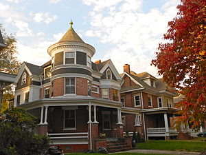
2105 Baynard Blvd.
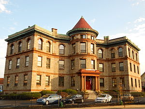
No. 30 School

2401 Baynard Blvd.


Education[]
It is in the Red Clay Consolidated School District.[3] It is zoned to Evan G. Shortlidge Academy (Kindergarten-Grade 2),[4] Emalea P. Warner Elementary School (grades 2–5),[5] Skyline Middle School (6-8),[6] and John Dickinson School (9-12).[7]
References[]
- ^ a b "National Register Information System". National Register of Historic Places. National Park Service. July 9, 2010.
- ^ Jean Athan (May 1978). "National Register of Historic Places Inventory/Nomination: Baynard Boulevard Historic District". and Accompanying 32 photos
- ^ "2020 CENSUS - SCHOOL DISTRICT REFERENCE MAP: New Castle County, DE" (PDF). U.S. Census Bureau. Retrieved 2021-06-18. - Compare to school boundary maps.
- ^ "Shortlidge_Warner_2016.pdf" (PDF). Red Clay Consolidated School District. Retrieved 2021-07-03.
- ^ "Warner_Shortlidge_2016.pdf" (PDF). Red Clay Consolidated School District. Retrieved 2021-07-03.
- ^ "Skyline_2016.pdf" (PDF). Red Clay Consolidated School District. Retrieved 2021-07-03.
- ^ "Dickinson_City_2016.pdf" (PDF). Red Clay Consolidated School District. Retrieved 2021-07-03.
![]() Media related to Baynard Boulevard Historic District at Wikimedia Commons
Media related to Baynard Boulevard Historic District at Wikimedia Commons
| Topics |  | |
|---|---|---|
| Lists by county | ||
| Lists by city | ||
| Other lists | ||
| ||
- American middle class
- Queen Anne architecture in Delaware
- Colonial Revival architecture in Delaware
- Tudor Revival architecture in Delaware
- Historic districts in Wilmington, Delaware
- Historic districts on the National Register of Historic Places in Delaware
- National Register of Historic Places in Wilmington, Delaware
- Delaware Registered Historic Place stubs