Bayola (Santurce)
Bayola | |
|---|---|
 A building on Calle Estrella in Bayola | |
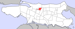 Map of Santurce barrio with Bayola highlighted | |
| Coordinates: 18°27′05″N 66°03′58″W / 18.4513086°N 66.0661980°WCoordinates: 18°27′05″N 66°03′58″W / 18.4513086°N 66.0661980°W | |
| Commonwealth | |
| Municipality | |
| Barrio | Santurce |
| Area | |
| • Total | .03 sq mi (0.08 km2) |
| • Land | .03 sq mi (0.08 km2) |
| • Water | 0 sq mi (0 km2) |
| Elevation | 10 ft (3 m) |
| Population (2010) | |
| • Total | 748 |
| • Density | 24,933.3/sq mi (9,626.8/km2) |
| Source: 2010 Census | |
| Time zone | UTC−4 (AST) |

Bayola is one of the forty subbarrios of Santurce, San Juan, Puerto Rico.
It's located between Expreso Baldorioty de Castro to the south, Calle Wilson to the north, Avenida de Diego to the east and Primavera Street to the west.
Bayola comprises just 4 streets. These are Calle Estrella, Calle Tres Hermanos, Calle Washington and Calle Julian Blanco.
Demographics[]
In 2000, Bayola had a population of 564.[3]
In 2010, Bayola had a population of 748 and a population density of 24,933.3 persons per square mile.[1]
Gallery[]

Street scene in Bayola in 2019

See also[]
References[]
- ^ a b Puerto Rico:2010:population and housing unit counts.pdf (PDF). U.S. Dept. of Commerce, Economics and Statistics Administration, U.S. Census Bureau. 2010.
- ^ U.S. Geological Survey Geographic Names Information System: Bayola Subbarrio
- ^ Puerto Rico 2000: Population and Housing Unit Counts
This San Juan, Puerto Rico location article is a stub. You can help Wikipedia by . |
Categories:
- Santurce, San Juan, Puerto Rico
- Municipality of San Juan
- Puerto Rico Senatorial district I geography stubs