Bedni Bugyal
| Bedni Bugyal | |
|---|---|
 Bedini Bugyal | |
| Highest point | |
| Elevation | 3,354 m (11,004 ft) |
| Coordinates | 30°12′22″N 79°39′47″E / 30.206°N 79.663°E |
| Geography | |
| Location | Chamoli, Uttarakhand, India |
| Parent range | Garhwal Himalaya |


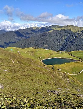
Bedni bugyal green
Bedni Bugyal is a Himalayan Alpine meadow and a hill station , situated at an elevation of 3,354 metres (11,004 ft) in the Chamoli district of Uttarakhand state of India. Bedni Bugyal falls on the way to Roopkund near Wan village.[1] Trisul and Nanda Ghunti are clearly visible from here. This lush green meadow is adorned with blooms in a wide range of varieties. There is a small lake named Vaitarani (Bedni Kund), situated amidst the meadow. The rich flora of the area includes 'Brahm Kamal' or Saussurea obvallata.
References[]
- ^ "Three close-to-home quick getaways for the extended weekends" – via The Economic Times.
Categories:
- Geography of Chamoli district
- Hiking trails in Uttarakhand