Belarus–Lithuania border
| Belarus–Lithuania border | |
|---|---|
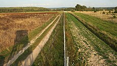 Belarus–Lithuania border near Sakalinė | |
| Characteristics | |
| Entities | |
| Length | 678.8 km (421.8 mi) |
| History | |
| Established | 1920 1940 |
| Current shape | 6 February 1995 |
| Treaties | Soviet–Lithuanian Peace Treaty Agreement between the Republic of Lithuania and the Republic of Belarus concerning the State Border between Lithuania and Belarus[1] |

The Belarus–Lithuania border is an international border almost 678.8 km (421.8 mi)[2] in length between the Republic of Belarus (CIS member) and the Republic of Lithuania (EU member). It is an external border of the European Union as well as the western border of the Commonwealth of Independent States. 379.9 km (236.1 mi) of the border is on land, while 298.9 km (185.7 mi) are on water, crossing lakes, e.g. Lake Drūkšiai and following some rivers, e.g. Dysna River and Neman River.
Both countries follow the most basic rules of the freedoms of the air meaning for example that aircraft can fly over the border and through a country without special permission.[citation needed] However on 23 May 2021, Ryanair Flight 4978, an intra-EU flight with 171 passengers on board, crossing Belarusian airspace, was intercepted by a Belarusian MiG-29 and forced to land at Minsk Airport, where two of the passengers were arrested, which was objected by many governments and called air hijacking by a state.
History[]
Historical borders of and within the Grand Duchy of Lithuania and later, following the partitions of the Polish–Lithuanian Commonwealth, governorates of the Russian Empire varied significantly throughout the history and at times bore little resemblance to the modern borders. The early formations of the current border originate after the World War I, following the establishment of the Republic of Lithuania (1918–1940) and the Lithuanian–Soviet War. The Soviet-Lithuanian Peace Treaty was signed on 12 July 1920, defining and recognizing the eastern border of Lithuania, even though it was de facto controlled by Poland due to the Polish–Lithuanian War and Polish–Soviet War.[3] It was similar to the present border, but the Vilnius region was de facto controlled by Poland. Following the World War II and the Soviet occupation of the Baltic states, a new border was established between the Lithuanian Soviet Socialist Republic and Byelorussian Soviet Socialist Republic within the Soviet Union. It is the basis of the current border which had remained largely stable since 1940.[4]
The border is defined by the treaty of 6 February 1995 between the two countries.[1] The border demarcation of the border was completed in 2007.[2] Since 2004 the border has served as the external border of the European Union and, since 2007, the Schengen Area. These developments brought increased border controls and stricter visa requirements for crossing between the two countries. An agreement signed in 2010 aims to implement simplified traveling for people living within 50 km (31 mi) of the border.[5]
Definition of the border[]

The treaty defines the border as starting at the border tripoint of Lithuania, Latvia and Belarus, where there is a monument (55°40′50″N 26°37′48″E / 55.68056°N 26.63000°E). It goes southeast across Lake Drūkšiai, following river Apyvardė, across lakes Apvardai and Prūtas, further following Dysna River to the east, and further to Adutiškis railway station. It further goes north of Belarusian settlement Lyntupy, east of the Lithuanian settlement Šumskas, across the road Vilnius - Maladzyechna, goes around the area of Lithuanian settlement Dieveniškės from the east, south and west, goes to the North of Belarusian settlement Bieniakoni, crosses the road Vilnius-Lida and further follows Šalčia river. It further continues to the south of Lithuanian city Eišiškės, follows Načia river, goes to the south of Lithuanian settlement Dubičiai, reaches the source of Kotra River and further follows this river, then across lakes Grūda ir Dubas. It further crosses the railroad Vilnius-Grodno next to the stop Senovė, and the railroad to Druskininkai to the north of the stop Pariečė, continuing west towards Neman river and up against the current, and further following Mara river to the border tripoint of Belarus, Lithuania and Poland (53°57′22″N 23°30′54″E / 53.95611°N 23.51500°E).[6]
 WikiMiniAtlas
2021 migrant crisis[]

In June 2021, Lithuanian officials claimed that Belarusian authorities could encourage illegal migration from Iraq and Syria to Lithuania by organizing groups of refugees and helping them to cross the Belarusian-Lithuanian border.[7][8] State-owned travel company Tsentrkurort was named as one of the performers of illegal migration.[8] It was assumed that the state support of illegal migration could be carried out for political reasons.[8] Illegal migration from Belarus forced Lithuania to declare state of emergency on 7 July 2021.[9]
Lithuania is building a border barrier to stem the flow of illegal crossings.[10] On 5 August 2021, the chief of the Lithuanian State Border Guard Service presented a project of the proposed barrier for the entire Belarus-Lithuania border which would be 4 m (13 ft) high and would use multiple layers of the Concertina wire.[11] The cost of the project is estimated at €150 million and the Lithuanian parliament is set to consider it as a matter of urgency.
| Year | Number of illegal migrants crossed Belarus—Lithuania border |
|---|---|
| 2017 | 72 |
| 2018 | 104 |
| 2019 | 46 |
| 2020 | 81 |
| 2021 (by 7 August)[12] | 4,112 |
See also[]
References[]
- ^ Jump up to: a b "Lietuvos Respublikos ir Baltarusijos Respublikos sutartis dėl Lietuvos ir Baltarusijos valstybės sienos" [Agreement between the Republic of Lithuania and the Republic of Belarus concerning the State Border between Lithuania and Belarus]. Office of the Seimas of the Republic of Lithuania (in Lithuanian). 6 February 1995. Retrieved 9 August 2021.
- ^ Jump up to: a b "Valstybinės sienos demarkavimas" (in Lithuanian). National Land Service under the Ministry of Agriculture. 28 March 2013. Retrieved 2 August 2021.
- ^ Tsikhamirau, Aliaksandr (2012). "The main stages of the formation of the Belarus identity: historical retrospective" (PDF). Politikos mokslų almanachas.
- ^ Digrytė, Eglė. "Lithuanian-Belarusian border: Divided villages, divided lives". 15min. Archived from the original on 10 April 2021. Retrieved 1 September 2016.
- ^ "R.Palaitis: "Iki bevizio režimo su Baltarusijos pasienio zona trūksta tik pasikeitimo notomis"". Archived from the original on 13 December 2014. Retrieved 1 September 2016.
- ^ "Lietuvos Respublikos Seimas - Dokumento tekstas". Office of the Seimas of the Republic of Lithuania. Retrieved 2 August 2021.
- ^ Lithuania says Belarus could be behind recent migrant influx
- ^ Jump up to: a b c Belarus ‘weaponising’ illegal migration, Lithuania says
- ^ Lithuania declares state of emergency over migrant arrivals from Belarus
- ^ "Lithuania plans barrier on Belarus border to stem migrant flow". BBC News. 7 July 2021. Retrieved 11 July 2021.
- ^ "VSAT vadas pristatė, kaip atrodytų tvora Lietuvos ir Baltarusijos pasienyje: kainuotų apie 150 mln. eurų, statybos truktų dvejus metus". LRT (in Lithuanian). 5 August 2021. Retrieved 8 August 2021.
- ^ "Neteisėtos migracijos stebėsena (nuo 2021-01-01)". Department of Statistics, Lithuania. 7 August 2021. Retrieved 7 August 2021.
- Belarus–Lithuania border
- 1995 establishments in Belarus
- 1995 establishments in Lithuania
- 1995 in international relations
- Borders of Belarus
- Borders of Lithuania
- International borders
- Internal borders of the Soviet Union
- European Union external borders