Bellary
Bellary | |
|---|---|
City | |
| Ballari | |
 | |
| Nickname(s): Steel City | |
 Bellary Location in Karnataka, India | |
| Coordinates: 15°06′N 76°55′E / 15.100°N 76.917°ECoordinates: 15°06′N 76°55′E / 15.100°N 76.917°E | |
| Country | |
| State | Karnataka |
| Region | Hyderabad-Karnataka, Deccan |
| District | Bellary |
| Government | |
| • Type | Municipal Corporation |
| • Body | Bellary Urban Development Authority |
| • Mayor | Ramana[1] |
| • Deputy Mayor | Ms. Malan Bee S[1] |
| • Commissioner | Sri.P.G.Ramesh[5] |
| Area | |
| • City | 89.95 km2 (34.73 sq mi) |
| Elevation | 485 m (1,591 ft) |
| Population (2011 census)[2] | |
| • Rank | 111 (India), 8th (Karnataka) |
| • Urban | 410,445 (BUDA) |
| • Rural | 360,484 |
| • Metro | 770,929 |
| Demonym(s) | Ballarian |
| Languages | |
| • Official | Kannada |
| Time zone | Indian Standard Time |
| PIN | |
| ISO 3166 code | IN-KA |
| Vehicle registration | KA-34 |
| Sex ratio | 1.04[2] ♂/♀ |
| Literacy | 79%[2] |
| Distance from Bangalore | 311 kilometres (193 mi) (land) |
| Website | www |


Bellary, officially Ballari, in the eponymous Bellary district, is a major city in the state of Karnataka, India. It is 311 km (193 mi) from the state capital of Bangalore and 358 km (222 mi) from Hyderabad. Bellary has an urban population of 410,445 and metro population of 770,929 making it one of the most populous cities of Karnataka. Bellary was a part of the first Indian commercial flight from Karachi to Madras on 15 October 1932 by JRD Tata.
History
The Ballari city municipal council was upgraded to a city corporation in 2004.[6]
The Union Ministry of Home Affairs of the Government of India approved a proposal[7] to rename the city in October 2014 and Bellary was renamed to "Ballari" on 1 November 2014.[8]
Geography and climate

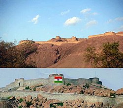
Bellari is located at 15°09′N 76°56′E / 15.15°N 76.93°E. It has an average elevation of 495 metres (1,624 ft).[citation needed] The city stands in the midst of a wide, level plain of black cotton soil.[9] Granite rocks and hills form a prominent feature of Bellari. The city is spread mainly around two hills of granite composition, the Bellary Gudda and the Kumbara Gudda.
Bellary Gudda has a circumference of nearly 2 miles (3.2 km) and a height of 480 feet (150 m). The length of this rock from north-east to south-west is about 1,150 ft (350 m). To the east and south lies an irregular heap of boulders, to the west there is an unbroken monolith, and the north is walled by bare, rugged ridges.[9]
Kumbara Gudda looks like the profile of a human face from the south-east. It is also known as Face Hill.[9]
| hideClimate data for Bellary (1981–2010, extremes 1901–2012) | |||||||||||||
|---|---|---|---|---|---|---|---|---|---|---|---|---|---|
| Month | Jan | Feb | Mar | Apr | May | Jun | Jul | Aug | Sep | Oct | Nov | Dec | Year |
| Record high °C (°F) | 37.6 (99.7) |
40.5 (104.9) |
43.0 (109.4) |
44.7 (112.5) |
44.6 (112.3) |
44.7 (112.5) |
39.5 (103.1) |
39.0 (102.2) |
38.4 (101.1) |
39.0 (102.2) |
38.4 (101.1) |
35.6 (96.1) |
44.7 (112.5) |
| Average high °C (°F) | 31.4 (88.5) |
34.4 (93.9) |
38.1 (100.6) |
40.4 (104.7) |
39.6 (103.3) |
35.3 (95.5) |
32.7 (90.9) |
31.9 (89.4) |
32.3 (90.1) |
31.8 (89.2) |
30.8 (87.4) |
30.2 (86.4) |
34.1 (93.4) |
| Average low °C (°F) | 15.6 (60.1) |
18.1 (64.6) |
21.1 (70.0) |
23.9 (75.0) |
24.4 (75.9) |
23.3 (73.9) |
23.0 (73.4) |
22.7 (72.9) |
21.9 (71.4) |
20.9 (69.6) |
18.3 (64.9) |
15.6 (60.1) |
20.7 (69.3) |
| Record low °C (°F) | 7.0 (44.6) |
8.5 (47.3) |
10.0 (50.0) |
13.0 (55.4) |
14.5 (58.1) |
14.8 (58.6) |
15.5 (59.9) |
15.0 (59.0) |
15.0 (59.0) |
12.5 (54.5) |
8.4 (47.1) |
8.0 (46.4) |
7.0 (44.6) |
| Average rainfall mm (inches) | 2.9 (0.11) |
2.3 (0.09) |
6.0 (0.24) |
17.2 (0.68) |
54.3 (2.14) |
59.2 (2.33) |
42.6 (1.68) |
70.0 (2.76) |
111.0 (4.37) |
89.0 (3.50) |
39.5 (1.56) |
5.5 (0.22) |
499.5 (19.67) |
| Average rainy days | 0.5 | 0.2 | 0.6 | 1.5 | 3.4 | 3.8 | 3.8 | 4.7 | 5.4 | 5.8 | 2.4 | 0.5 | 32.7 |
| Average relative humidity (%) (at 17:30 IST) | 43 | 37 | 30 | 29 | 34 | 50 | 56 | 58 | 58 | 62 | 56 | 50 | 47 |
| Source: India Meteorological Department[10][11] | |||||||||||||
Demographics
According to the 2011 Census of India, the urban population of Bellary was 410,445; of whom 206,149 were male and 204,296 female. 280,610 of the population were literate and 52,413 of the population were under 6 years of age this makes it the 8th most populous city of karnataka.[12] The population in 2001 was recorded as 316,766.[13]
Industries
Textiles and garments
- Cotton processing
- With cotton being one of the major agricultural crops around Bellary historically, the city has had a thriving cotton processing industry in the form of ginning, spinning and weaving plants. The earliest steam cotton-spinning mill was established in 1894, which by 1901 had 17,800 spindles, and employed 520 hands.[9]
- The city continues to thrive in this sector with one spinning mill and numerous cotton ginning and pressing mills, hand looms and power looms.[14]
- Garment manufacture
- Bellari has a historic garment industry dating back to the First World War period, when the Marathi speaking "Darji" (tailor) community with its native skills in tailoring migrated from the current Maharashtra region to stitch uniforms for the soldiers of the colonial British Indian Army stationed at Bellary. After the war, the community switched to making uniforms for school children, and gradually the uniforms made here became popular all over the country.[15][16]
- Currently, Bellari is well known for its branded and unbranded denim garments, with brands like Point Blank, Walker, Dragonfly and Podium being successfully marketed nationally and internationally.[16] There are about 260 denim garment units in Bellary with nearly 3000 families working in these units.[14]
Notable people
See Category:People from Bellary
- Basavarajeshwari – Politician and Industrialist
- Ravi Belagere – Actor, writer, novelist, journalist, publisher of the Hai Bengaluru Tabloid
- Naveen Chandra – Actor in Telugu film industry
- Manjula Chellur −1st Woman Chief Justice of Calcutta High Court
- Nagarur Gopinath – One of the pioneers of cardiothoracic surgery in India, credited with the first successful performance of open heart surgery in India in 1962. Recipient of Padma Shri (1974) and Dr. B. C. Roy Award (1978)
- Jayanthi – cinema actress, born in Bellary
- K. C. Kondaiah – Politician and industrialist
- Arcot Ranganatha Mudaliar – Former Deputy Collector of Bellary, politician and theosophist. He served as the Minister of Public Health and Excise for the Madras Presidency from 1926 to 1928.
- A. Sabhapathy Mudaliar – Philanthropist; The Women & Children's Hospital or The District Hospital was initially named after him, following his donation of land and building to the hospital.[9]
- Bellary Raghava (1880–1946) – Noted dramatist. The Raghava Kala Mandir auditorium in Bellary is named after him
- Suparna Rajaram – Distinguished Professor of Psychology at Stony Brook University
- Dharmavaram Ramakrishnamacharyulu (1853–1912) – Noted dramatist
- Bhargavi Rao – a Kannada-Telugu translator, winner of the prestigious Kendra Sahitya Academy award
- Kolachalam Srinivasa Rao (1854–1919) – Noted dramatist
- Gali Janardhan Reddy – Former minister and district in charge. He is one of the richest politicians in India
- B Sriramulu - Present Minister of Health and Family Welfare of Karnataka
- Tekur Subramanyam – Indian Freedom Fighter, First post-independence MP of Bellary, elected thrice in a row since 1952, political secretary to Prime Minister Jawaharlal Nehru[17][18][19]
- Ibrahim B. Syed – Indo-American Radiologist
References
Maps
General
- ^ Jump up to: a b "Bellary City Corporators". Archived from the original on 25 June 2011. Retrieved 5 February 2015.
- ^ Jump up to: a b c "District Census Handbook – Guntur" (PDF). Census of India. The Registrar General & Census Commissioner. p. 22. Retrieved 6 November 2016.
- ^ "Indiapost PIN Search for 'bellary'". Archived from the original on 4 May 2007. Retrieved 8 May 2007.
- ^ "PPP India STD Code Search for 'bellary'". Archived from the original on 4 May 2007. Retrieved 8 May 2007.
- ^ "Bellary City Staff". Archived from the original on 20 May 2006. Retrieved 5 February 2015.
- ^ "Karnataka. Bellary City Municipal Council upgraded to corporation". The Hindu. 26 September 2004. Archived from the original on 21 December 2016. Retrieved 8 December 2016.
- ^ "GOVERNMENT OF INDIA, MINISTRY OF HOME AFFAIRS" (PDF).
- ^ New City, Names to Karnatka. "New name for cities". The Hindu. Retrieved 1 November 2014.
- ^ Jump up to: a b c d e The Imperial Gazetteer of India, volume 7. Oxford: Clarendon Press. 1908. pp. 158–176.
- ^ "Station: Bellary Climatological Table 1981–2010" (PDF). Climatological Normals 1981–2010. India Meteorological Department. January 2015. pp. 119–120. Archived from the original (PDF) on 5 February 2020. Retrieved 18 April 2020.
- ^ "Extremes of Temperature & Rainfall for Indian Stations (Up to 2012)" (PDF). India Meteorological Department. December 2016. p. M90. Archived from the original (PDF) on 5 February 2020. Retrieved 18 April 2020.
- ^ "Census of India 2011". Census Commission of India. Retrieved 8 December 2016.
- ^ "Census of India 2001" (PDF). Census Commission of India. Retrieved 8 December 2016.
- ^ Jump up to: a b "Karnataka Handloom". Archived from the original on 27 September 2011. Retrieved 23 July 2010.
- ^ "Bellary Portal". Retrieved 23 July 2010.[permanent dead link]
- ^ Jump up to: a b "Jeans Industry in Bellary". Archived from the original on 22 December 2008. Retrieved 23 July 2010.
- ^ "This jailhouse has a rich past". 26 April 2010. Retrieved 4 June 2010.
- ^ "A Congress bastion since 1952". Archived from the original on 26 January 2013. Retrieved 4 June 2010.
- ^ "Caste will play a vital role in Bellary". Retrieved 4 June 2010.
External links
| Wikivoyage has a travel guide for Bellary. |
| Wikimedia Commons has media related to Bellary. |
| Authority control |
|---|
- Bellary
- 1808 establishments in British India
- Municipal corporations in Karnataka
- Cities in Karnataka