Belligné
Belligné | |
|---|---|
Part of Loireauxence | |
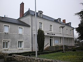 The town hall in Belligné | |
 Coat of arms | |
show Location of Belligné | |
 Belligné | |
| Coordinates: 47°28′06″N 1°01′36″W / 47.4683°N 1.0267°WCoordinates: 47°28′06″N 1°01′36″W / 47.4683°N 1.0267°W | |
| Country | France |
| Region | Pays de la Loire |
| Department | Loire-Atlantique |
| Arrondissement | Ancenis |
| Canton | Ancenis |
| Commune | Loireauxence |
| Area 1 | 32.8 km2 (12.7 sq mi) |
| Population (2017)[1] | 1,759 |
| • Density | 54/km2 (140/sq mi) |
| Time zone | UTC+01:00 (CET) |
| • Summer (DST) | UTC+02:00 (CEST) |
| Postal code | 44370 |
| Elevation | 47–94 m (154–308 ft) |
| 1 French Land Register data, which excludes lakes, ponds, glaciers > 1 km2 (0.386 sq mi or 247 acres) and river estuaries. | |


Belligné is a former commune in the Loire-Atlantique department in western France. On 1 January 2016, it was merged into the new commune of Loireauxence.[2]
Population[]
| Year | Pop. | ±% |
|---|---|---|
| 1793 | 2,200 | — |
| 1800 | 1,624 | −26.2% |
| 1806 | 1,976 | +21.7% |
| 1821 | 2,102 | +6.4% |
| 1831 | 2,163 | +2.9% |
| 1836 | 2,133 | −1.4% |
| 1841 | 2,047 | −4.0% |
| 1846 | 2,077 | +1.5% |
| 1851 | 2,204 | +6.1% |
| 1856 | 2,225 | +1.0% |
| 1861 | 2,227 | +0.1% |
| 1866 | 2,237 | +0.4% |
| 1872 | 2,221 | −0.7% |
| 1876 | 2,297 | +3.4% |
| 1881 | 2,280 | −0.7% |
| 1886 | 2,255 | −1.1% |
| 1891 | 2,164 | −4.0% |
| 1896 | 2,099 | −3.0% |
| 1901 | 1,951 | −7.1% |
| 1906 | 1,906 | −2.3% |
| 1911 | 1,887 | −1.0% |
| 1921 | 1,708 | −9.5% |
| 1926 | 1,645 | −3.7% |
| 1931 | 1,647 | +0.1% |
| 1936 | 1,553 | −5.7% |
| 1946 | 1,481 | −4.6% |
| 1954 | 1,462 | −1.3% |
| 1962 | 1,464 | +0.1% |
| 1968 | 1,418 | −3.1% |
| 1975 | 1,292 | −8.9% |
| 1982 | 1,324 | +2.5% |
| 1990 | 1,430 | +8.0% |
| 1999 | 1,453 | +1.6% |
| 2006 | 1,716 | +18.1% |
| 2009 | 1,750 | +2.0% |
See also[]
- Communes of the Loire-Atlantique department
References[]
External links[]
| Wikimedia Commons has media related to Belligné. |
| show Authority control |
|---|
This Loire-Atlantique geographical article is a stub. You can help Wikipedia by . |
Categories:
- Former communes of Loire-Atlantique
- Populated places disestablished in 2016
- Loire-Atlantique geography stubs