Berkley Common Historic District
Berkley Common Historic District | |
 Granite marker for Berkley Common. Berkley public library in background. | |
 | |
| Location | N. Main, S. Main, Porter & Locust Sts., Berkley, Massachusetts |
|---|---|
| Coordinates | 41°50′46″N 71°4′55″W / 41.84611°N 71.08194°WCoordinates: 41°50′46″N 71°4′55″W / 41.84611°N 71.08194°W |
| NRHP reference No. | 15000980[1] |
| Added to NRHP | January 19, 2016 |


The Berkley Common Historic District is a historic district encompassing the historic heart of Berkley, Massachusetts. The town's village center is located near its geographic center, roughly midway between Massachusetts Route 24 and the Taunton River. Its central focus is the triangular town common, bounded by Main, Locust, and Porter Streets. The common is flanked by a number municipal and civic buildings, and has been the town's focus of civic life for more about 275 years.[2]
The district was added to the National Register of Historic Places in 2016.[1]
Gallery[]

Sign for the Berkley Common Historic District
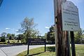
Another sign, this one in front of the Middle School and cemetery
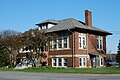
Old Town Hall

New Town Hall

Berkley Common, church in the background
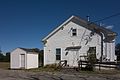
The library
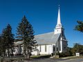
Berkley Congregational Church


See also[]
| Wikimedia Commons has media related to Berkley Common Historic District (Massachusetts). |
References[]
- ^ a b "National Register Information System". National Register of Historic Places. National Park Service. April 15, 2008.
- ^ "MACRIS inventory record for Berkley Village-Berkley Common Area". Commonwealth of Massachusetts. Retrieved 2016-02-04.
| Topics |  | ||||||||||||||||
|---|---|---|---|---|---|---|---|---|---|---|---|---|---|---|---|---|---|
| Lists by county | |||||||||||||||||
| Lists by city |
| ||||||||||||||||
| Other lists | |||||||||||||||||
| |||||||||||||||||
- Historic districts in Bristol County, Massachusetts
- National Register of Historic Places in Bristol County, Massachusetts
- Berkley, Massachusetts
- Historic districts on the National Register of Historic Places in Massachusetts
- Bristol County, Massachusetts Registered Historic Place stubs