Bettiah
This article possibly contains original research. (May 2016) |
Bettiah | |
|---|---|
City | |
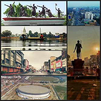 Anticlockwise from top left - Saheed Park, Sagar pokhra and Shiv Mandir, Supriya Cinema road, Bettiah auditorium and Maharaja Stadium, Gandhi statue at Hariwatika Chowk, Aeria view of Station chowk. | |
 Bettiah Location in Bihar, India | |
| Coordinates: 26°48′05″N 84°30′10″E / 26.80139°N 84.50278°ECoordinates: 26°48′05″N 84°30′10″E / 26.80139°N 84.50278°E | |
| Country | India |
| State | Bihar |
| District | West Champaran |
| Founded by | Gangeshwar Dev |
| Government | |
| • Type | Mayor-council |
| • Body | Bettiah Municipal corporation |
| Area | |
| • City | 24 km2 (9 sq mi) |
| • Urban | 64 km2 (25 sq mi) |
| Elevation | 65 m (213 ft) |
| Population (2020)as estimated | |
| • City | 309,379 |
| • Rank | 14th(as in 2011)in Bihar |
| • Density | 13,000/km2 (33,000/sq mi) |
| • Urban | 434,426 |
| Language | |
| • Official | Hindi[1] |
| • Additional official | Urdu[1] |
| • Regional | Bhojpuri[2] |
| Time zone | UTC+5:30 (IST) |
| PIN | 845438 |
| Area code(s) | 06254 |
| ISO 3166 code | IN-BR |
| Vehicle registration | BR-22 |
| Sex ratio | 53% male : 47% female ♂/♀ |
| Lok Sabha constituency | Paschim Champaran/was before Bettiah |
| Vidhan Sabha constituency | Bettiah |
| Website | westchamparan |

Bettiah is a city and administrative headquarters of West Champaran district (Tirhut Division)[3] - (Tirhut), near Indo-Nepal border, 225 kilometres (140 mi) north-west of Patna, in Bihar state of India.
History[]

In 1244 A.D., Gangeshwar Dev, a Bhumihar Brahmin of "Jaitharia" clan, settled at Jaithar in Champaran.[4] One of his descendants, Agar Sen, acquired large territory in the reign of Emperor Jehangir and was bestowed the title of 'Raja' by Emperor Shah Jahan. In 1659, he was succeeded by his son Raja Guj Singh, who built the palace of the family at Bettiah. He died in 1694 A.D. The palace stands today but serves as marketplace.
In 1765, when the East India Company acquired the Diwani, Bettiah Raj held the largest territory under its jurisdiction.[5] It consisted of all of Champaran except for a small portion held by the Ram Nagar Raj (also held by Bhumihar family).[5]
Maharaja Sir Harendra Kishore Singh was the last king of Bettiah Raj.[4] He was born in 1854 and succeeded his father, the late Maharaja Rajendra Kishore Singh Bahadur in 1883. In 1884, he received the title of Maharaja Bahadur as a personal distinction and a Khilat and a sanad from the hands of the Lieutenant Governor of Bengal, Sir Augustus Rivers Thompson. He was created a Knight Commander of the Most Eminent Order of the Indian Empire on 1 March 1889. He was appointed a member of the Legislative Council of Bengal in January 1891. He was also a member of The Asiatic Society He was the last ruler of Bettiah Raj. Maharaja Sir Harendra Kishore Singh Bahadur died heirless on 26 March 1893, leaving behind two widows, Maharani Sheo Ratna Kunwar and Maharani Janki Kunwar.
There are a few institutes named for queen Maharani Janki Kunwar, such as M.J.K College and M.J.K Hospital.
The Bettiah Gharana was one of the oldest style of vocal music.[6] Madhuban was part of the erstwhile 'Bettiah Raj'. Internal disputes and family quarrels divided the Bettiah Raj in course of time. Madhuban Raj was created as a consequence.
A section of Dhrupad singers of dilli gharana (Delhi Gharana) from Mughal emperor Shah Jahan’s court had migrated to Bettiah under the patronage of Bettiah Raj and thus was sown the seed of Bettiah Gharana.[6] The famous Dagar brothers had praised the Bettiah Dhrupad singers and some of them were invited to the Bharat Bhavan in Bhopal to perform with other accomplished singers in 1990.[6]
On 26 December 2020, Bettiah became a municipal corporation.[7]
Geography[]
Climate[]
The climate of Bettiah is characterised by high temperatures and high precipitation especially during the monsoon season. The Köppen Climate Classification sub-type for this climate is "Cfa" (Humid Subtropical Climate).
| hideClimate data for Bettiah | |||||||||||||
|---|---|---|---|---|---|---|---|---|---|---|---|---|---|
| Month | Jan | Feb | Mar | Apr | May | Jun | Jul | Aug | Sep | Oct | Nov | Dec | Year |
| Average high °C (°F) | 23.3 (73.9) |
26.3 (79.4) |
32.4 (90.3) |
37.3 (99.1) |
38.7 (101.7) |
37 (99) |
33.5 (92.3) |
32.8 (91.1) |
33.3 (91.9) |
32.3 (90.1) |
29.2 (84.6) |
24.6 (76.2) |
31.7 (89.1) |
| Daily mean °C (°F) | 16.2 (61.1) |
18.7 (65.6) |
24.2 (75.5) |
29.2 (84.6) |
32 (89) |
32 (89) |
29.6 (85.3) |
29.1 (84.4) |
28.9 (84.1) |
26.6 (79.9) |
21.9 (71.4) |
17.4 (63.3) |
25.4 (77.8) |
| Average low °C (°F) | 9.1 (48.3) |
11.1 (51.9) |
16.1 (60.9) |
21.2 (70.2) |
24.6 (76.2) |
26.2 (79.1) |
25.7 (78.3) |
25.4 (77.8) |
24.6 (76.3) |
21.0 (69.8) |
14.6 (58.2) |
10.2 (50.4) |
19.2 (66.5) |
| Average precipitation mm (inches) | 13 (0.5) |
13 (0.5) |
10 (0.4) |
18 (0.7) |
46 (1.8) |
200 (7.7) |
380 (14.9) |
360 (14) |
230 (8.9) |
66 (2.6) |
5.1 (0.2) |
5.1 (0.2) |
1,330 (52.4) |
| Average precipitation days | 1.4 | 1.1 | 1.1 | 1.0 | 2.1 | 5.4 | 10.9 | 11.9 | 7.3 | 2.4 | 0.6 | 0.7 | 45.7 |
| Mean daily sunshine hours | 11.1 | 11.7 | 12.4 | 13.2 | 13.9 | 14.2 | 14.1 | 13.5 | 12.7 | 11.9 | 11.2 | 10.9 | 12.6 |
| Source: Weatherbase[8] | |||||||||||||
Connectivity[]
Railway[]

Bettiah is connected to different cities of India through railways. Bettiah railway station is the main railway station serving the city. Direct trains are available to all the major destinations across India like Patna, Delhi, Mumbai, Kolkata, Guwahati, Ahemdabad, Lucknow, Jaipur, Jammu & Katra, etc.
Roadway[]
National Highway 727 and State Highway 54 passes through the city.
The National Highway Authority of India (NHAI) has notified a new Patna-Bettiah road as National Highway 139W, setting the state for construction of a high-quality four-lane road between the two towns that would reduce the distance between them to 167 kilometres from the current 200-odd km and travel time to around 2 hours.[9]
NH 139W is going to be a part of bharat mala project phase 2.
Airway[]
The nearest airport is located in Gorakhpur which is about 145 km (90 mi) from Bettiah. The second nearest airport and nearest airport in bihar is Jay Prakash Narayan Airport located in Patna which is about 200 km (120 mi) via Muzaffarpur and 177 km (110 mi) via areraj.
Demographics[]

As of 2011 Indian Census, Bettiah NP had a total population of 132,209, of which 69,529 were males and 62,680 were females. Population within the age group of 0 to 6 years was 18,995. The total number of literates in Bettiah was 91,298, which constituted 69.1% of the population with male literacy of 72.7% and female literacy of 64.9%. The effective literacy rate of 7+ population of Bettiah was 80.6%, of which male literacy rate was 85.0% and female literacy rate was 75.8%. The Scheduled Castes and Scheduled Tribes population was 8,266 and 828 respectively. Bettiah had 24463 households in 2011.[10]
The effective literacy (literacy of people above the age of 7) was 80.89.[11] The urban agglomeration includes Bettiah (municipal corporation), Tola Mansaraut (census town), Kargahia Purab (census town) and Hat Saraiya (census town).[12] Tola San Saraiyan new town aided village. The new Gopalganj-Bettiah Road passed through this new town aided village. Through this new road a distance of 60 km (37 mi) become shorten for Gopalganj-Bettiah.[13]
Education[]
Schools[]
- St. Xavier's Higher Secondary School, Bettiah
- Khrist Raja High School, Bettiah
- St. Joseph's School, Bettiah[14]
- Assembly of God Church School, Bettiah[15]
- St. Michael's Academy, Bettiah[16]
- St. Teresa's Girls' Senior Secondary School, Bettiah[17]
- Alok Bharati Shikshan Sansthan English Medium School, Bettiah[18]
- St. Mary/Remijius High School, Bettiah[19]
- Notre Dame Public School
- R.L international School, Bettiah[20]
- Kendriya Vidyalaya, Bettiah[21]

St. Xavier's Higher Secondary School

St. Joseph's School
St. Michael's Academy

Khrist Raja High School

Assembly of God Church School


Colleges[]
- Government Medical College, Bettiah
- Government Engineering College, West Champaran
- Maharani Janki Kunwar College, Bettiah[22]
- Ram Lakhan Singh Yadav College, Bettiah
- Gulab Memorial College, Bettiah
- MRRG College, Bettiah[23]
- MNM Mahila College, Bettiah
- St. Teresa Primary Teachers Training College, Bettiah[24]
- Chanakya College of Education, Bettiah[25]
- Raj Inter College, Bettiah[26]

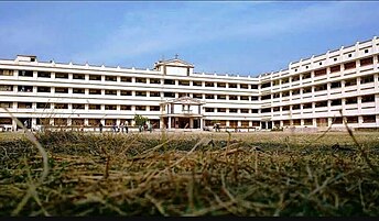
Inside view of Government Medical College
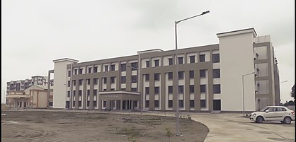
Administrative block of Government Engineering College Bettiah, W.Champaran

Chanakya College of education


Notable people[]
- Manoj Bajpai, Indian film actor
- Prakash Jha, Indian film producer, director, and screenwriter
- Renu Devi, first female and 7th Deputy Chief Minister of Bihar
- Sanjay Jaiswal, politician and president of Bharatiya Janata Party, Bihar
- Krishna Kumar Mishra, former member of Legislative assembly, Chanpatia (Bihar)
- Vikas Mishra, former Vice-Chancellor, Kurukshetra University
- Gopal Singh Nepali, Hindi poet and Bollywood lyricist
- Gauri Shankar Pandey, former member of Legislative assembly, Bettiah (Bihar)
- Kedar Pandey, 14th Chief Minister of Bihar
- Raj Kumar Shukla, Indian independence activist
See also[]
- Bettiah Raj
- Bettiah Christians
- West Champaran district
- List of cities in Bihar
- Champaran Satyagraha
- Paschim Champaran (Lok Sabha constituency)
References[]
- ^ Jump up to: a b "52nd Report of the Commissioner for Linguistic Minorities in India" (PDF). nclm.nic.in. Ministry of Minority Affairs. Archived from the original (PDF) on 25 May 2017. Retrieved 23 March 2019.
- ^ "Bhojpuri". Ethnologue. Retrieved 8 September 2020.
- ^ "Tirhut Division". tirhut-muzaffarpur.bih.nic.in. Archived from the original on 16 March 2015.
- ^ Jump up to: a b Lethbridge, Sir Roper (2005). The Golden Book of India: A Genealogical and Biographical Dictionary of the Ruling Princes, Chiefs, Nobles, and Other Personages, Titled Or Decorated of the Indian Empire. Aakar Books. p. 67. ISBN 978-81-87879-54-1. Retrieved 19 January 2020.
- ^ Jump up to: a b Ram, Bindeshwar (1998). Land and society in India: agrarian relations in colonial North Bihar. Orient Blackswan. ISBN 978-81-250-0643-5.
- ^ Jump up to: a b c "Many Bihari artists ignored by SPIC MACAY". The Times of India. 13 October 2001. Archived from the original on 23 October 2012. Retrieved 16 March 2009.
- ^ "पश्चिम चं���ारण में बेतिया बना नगर निगम, अब नागरिक सुविधाओं में होगा इजाफा". Dainik Jagran (in Hindi). 26 December 2020. Retrieved 29 March 2021.
- ^ "Weatherbase.com". Weatherbase. 2015. Archived from the original on 4 March 2016. Retrieved on 27 August 2015.
- ^ "New Patna-Bettiah NH gets nod, to cut travel time to 2.5 hours". Retrieved 10 July 2021.
- ^ "Census of India: Bettiah". www.censusindia.gov.in. Retrieved 5 December 2019.
- ^ "Urban Agglomerations/Cities having population 1 lakh and above" (PDF). censusindia.gov.in. Retrieved 29 March 2021.
- ^ "Constituents of urban Agglomerations Having Population 1 Lakh & above" (PDF). Provisional Population Totals, Census of India 2011. Archived (PDF) from the original on 6 March 2016. Retrieved 16 April 2012.
- ^ Kumar, Arun (14 March 2016). "Need to shun politics for Bihar's growth: Nitish". Hindustan Times. Retrieved 2 April 2021.
- ^ "St. Joseph's School Bettiah". Retrieved 1 May 2021.
- ^ "AGCS". Retrieved 1 May 2021.
- ^ "St. Michael's Academy Bettiah". Retrieved 3 May 2021.
- ^ "ST. TERESA'S-GIRLS SENIOR SECONDARY SCHOOL, BETTIAH". Retrieved 5 May 2021.
- ^ "Alok Bharati English Medium School". Retrieved 28 June 2021.
- ^ "www.stremijius.online". Retrieved 28 June 2021.
- ^ "R.L International School". Retrieved 6 July 2021.
- ^ "Home| KENDRIYA VIDYALAYA BEIA". Retrieved 19 May 2021.
- ^ "Welcome to Official Web Portal of Maharani Janki Kunwar College, Bettiah". Retrieved 1 May 2021.
- ^ "mrrg college". Retrieved 19 May 2021.
- ^ "St. Teresa's Primary Teacher's Education College Bettiah". Retrieved 28 June 2021.
- ^ "Chanakya College of Education, Bettiah". Retrieved 3 May 2021.
- ^ https://xn--11bunzmsdr5h2fbz.com/%E0%A4%B6%E0%A4%BF%E0%A4%95%E0%A5%8D%E0%A4%B7%E0%A4%BE/Alpaha/30.1.137/Raj_Inter_College_Bettiah/1654964734549271/
External links[]
- West Champaran Information Portal
- Official Website of Tirhut Division
- Galaxy International School Bettiah-GEG Group
| show Authority control |
|---|
- Cities and towns in West Champaran district