Bielawa
Bielawa | |
|---|---|
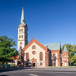 Corpus Christi church in Bielawa | |
 Flag  Coat of arms | |
 Bielawa | |
| Coordinates: 50°42′N 16°37′E / 50.700°N 16.617°E | |
| Country | |
| Voivodeship | Lower Silesian |
| County | Dzierżoniów |
| Gmina | Bielawa (urban gmina) |
| First mentioned | 1288 |
| Town rights | 1924 |
| Government | |
| • Mayor | Michał Glob Mika |
| Area | |
| • Total | 36.21 km2 (13.98 sq mi) |
| Highest elevation | 964 m (3,163 ft) |
| Lowest elevation | 280 m (920 ft) |
| Population (2019-06-30[1]) | |
| • Total | 29,971 |
| • Density | 830/km2 (2,100/sq mi) |
| Time zone | UTC+1 (CET) |
| • Summer (DST) | UTC+2 (CEST) |
| Postal code | 58-260 to 58-263 |
| Area code(s) | +48 74 |
| Car plates | DDZ |
| Website | http://www.bielawa.pl |

Bielawa [bʲɛˈlava] (![]() listen) (German: Langenbielau; Silesian: Bielawa), population 30,055 (2018),[2] is a town in southwestern Poland. Since 1999, it has been situated in Dzierżoniów County, Lower Silesian Voivodeship. From 1975 to 1998, it was part of the Wałbrzych Voivodeship.
listen) (German: Langenbielau; Silesian: Bielawa), population 30,055 (2018),[2] is a town in southwestern Poland. Since 1999, it has been situated in Dzierżoniów County, Lower Silesian Voivodeship. From 1975 to 1998, it was part of the Wałbrzych Voivodeship.
Bielawa lies in the central part of Lower Silesia, along the Bielawica stream in the Owl Mountains region. The town covers an area in excess of 36 square kilometres (14 sq mi).
Bielawa lies at an altitude range of 280 and 964 m above sea level, in the Owl Mountains. It is considered one of the most naturally beautiful regions of the Lower Silesian Voivodeship, and is a year-round tourist destination. Its outdoor attractions include four major hiking trails of varying difficulty in an 80 square kilometer scenic park, as well as cycling trails and ski lifts.
History[]
The oldest known mention of Bielawa dates back to 1288, when it was part of fragmented Piast-ruled Poland.[3] Its name is of Polish origin and is derived from the word biela, bila, current Polish biała ("white").[3]
In 1720 the first brick house was built in the village and in 1741 it was captured and afterwards annexed by Prussia. In 1805 Christian Dierig founded a weaving company (Christian Dierig AG). During the Napoleonic Wars, the village was occupied by France. In 1844 it was the site of the Weavers' Uprising, brutally crushed by the Prussians.[3] From 1871 to 1945 it was part of Germany. In 1891 the Dzierżoniów–Bielawa railway line opened. In 1924 Bielawa obtained town rights.[3] During World War II the Germans established the FAL Langenbielau II subcamp of the Gross-Rosen concentration camp in the town.[4] In 1945 it was captured by the Soviets and eventually reintegrated with Poland. Greeks, refugees of the Greek Civil War, settled in Bielawa in the 1950s.[5] Sometime around this time, the railway closed. Around 2000-2009 the Bielbaw factory closed, the company went bankrupt and was bought by Greno. In 2006 the bypass was opened . In 2018 the railway opened again. In 2019, hotel pod welcom sovom was bought and closed down for renovations.
Main sights[]
Bielawa has a rich choice of old architecture. At its center is the 19th-century Neo-Gothic Church of the Assumption with a 101 m tall tower, the third tallest in Poland. Other interesting buildings include a late-Renaissance palace originally built as a fortified manor house; the Church of the Corpus Christi, erected in 1743; and numerous 18th-century Baroque houses that were restored in the 19th and early 20th centuries. It is also a home to a number of medieval penitential crosses.
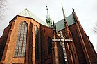
Church of the Assumption of Mary
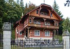
Pension Leśny Dworek

Palace

Town hall

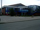
swimming pool "Aquarius" in Bielawa

Monument of Pope John Paul II in Bielawa
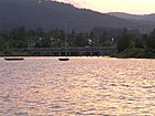
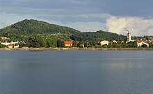
Lake in Bielawa


Population[]

Notable people[]
- Jeremiah Dencke (1725−1795), composer
- (1811–1867), German industrialist
- (1842–1916), German politician
- (1845–1931), German industrialist
- (1858–1936), Prussian General
- (1881–1967), German politician
- Georg Muschner (1885–1971), German cinematographer
- Walter Möse (1920–1944), Wehrmacht Oberfeldwebel
- (born 1929), author and wife of Ernst Engelberg
- (1929–2012), German industrialist
- Horst Weigang (born 1940), German athlete
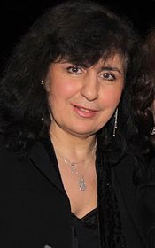
- Eleni Tzoka (born 1956), Polish singer
- Aleksandra Kwasniewska (born 1978), Polish singer
- Robert Skibniewski (born 1983), Polish basketball player
- Jarosław Kuźniar (born 1979), Polish journalist and TV presenter
- Janusz Góra (born 1963), Polish footballer
- Art Binkowski (born 1975), Polish-Canadian boxer
Twin towns – sister cities[]
 Chatham-Kent, Canada
 Ciechanów, Poland
 Hronov, Czech Republic
- Kostelec nad Orlicí, Czech Republic
 Lingen, Germany
Surroundings[]
- Gola Dzierżoniowska Castle
- Medieval town of Niemcza
- Cistercian monastery at Henryków
References[]
- ^ "Population. Size and structure and vital statistics in Poland by territorial division in 2019. As of 30th June". stat.gov.pl. Statistics Poland. 2019-10-15. Retrieved 2020-02-14.
- ^ "Statistics Population GUS" (PDF).
- ^ Jump up to: a b c d "Historia miasta". um.bielawa.pl (in Polish). Retrieved 14 March 2020.
- ^ "Subcamps of KL Gross- Rosen". Gross-Rosen Museum in Rogoźnica. Retrieved 14 March 2020.
- ^ Izabela Kubasiewicz, Emigranci z Grecji w Polsce Ludowej. Wybrane aspekty z życia mniejszości, p. 117 (in Polish)
- ^ "Main Page – Miasta Partnerskie". um.bielawa.pl (in Polish). Bielawa. Retrieved 2020-02-27.
External links[]
- Official town website
- Jewish Community in Bielawa on Virtual Shtetl
| Wikimedia Commons has media related to Bielawa. |
| hide | ||
|---|---|---|
| Urban gminas |
|  |
| Urban-rural gmina | ||
| Rural gminas | ||
Coordinates: 50°42′N 16°37′E / 50.700°N 16.617°E
| show Authority control |
|---|
- Cities and towns in Lower Silesian Voivodeship
- Dzierżoniów County
- Cities in Silesia