Big Hole (Oregon)
| Big Hole | |
|---|---|
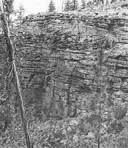 East rim of Big Hole, Oregon. | |
| Location | Lake County, Oregon, U.S. |
| Coordinates | 43°25′30″N 121°18′48″W / 43.4251292°N 121.3133502°WCoordinates: 43°25′30″N 121°18′48″W / 43.4251292°N 121.3133502°W[1] |
| Range | Cascade Range |
| Elevation | 4,613 feet (1,406 m) at the bottom[1] |
| Geology | Maar |
| Age | Possibly 20,000 years[2] |
| Topo map | USGS Big Hole |

Big Hole is a large maar (explosion crater) in the Fort Rock Basin of Lake County, central Oregon, northeast of Crater Lake, near Oregon Route 31. It is approximately 6000 ft (1820 m) across and 300 feet (91 m) deep.[3]
It is close to another smaller, but less-eroded maar crater, Hole-in-the-Ground.
See also[]
References[]
- ^ Jump up to: a b "Big Hole". Geographic Names Information System. United States Geological Survey. Retrieved 2008-11-13.
- ^ Lorenz, Volker (June 1970). "Some Aspects of the Eruption Mechanism of the Big Hole Maar, Central Oregon". GSA Bulletin. Geological Society of America. 81 (6): 1823–1830. doi:10.1130/0016-7606(1970)81[1823:SAOTEM]2.0.CO;2. Retrieved August 14, 2011.
- ^ McArthur, Lewis A.; McArthur, Lewis L. (2003) [1928]. Oregon Geographic Names (Seventh ed.). Portland, Oregon: Oregon Historical Society Press. ISBN 0-87595-278-X.
External links[]
- "CVO Menu - Fort Rock and Vicinity, Oregon". Cascades Volcano Observatory. United States Geological Survey. 2002-03-06. Retrieved 2008-04-29.
- Heiken, G. H.; Fisher, R. V.; Peterson, N. V. (1981). "A Field Trip to the Maar Volcanoes of the Fort Rock - Christmas Lake Valley Basin, Oregon". Geological Survey Circular. United States Geological Survey (838). Archived from the original on 2010-11-10. Retrieved 2008-04-29.
| Authority control |
|
|---|
This article about a specific United States geological feature is a stub. You can help Wikipedia by . |
Categories:
- Maars of Oregon
- Landforms of Lake County, Oregon
- United States geology stubs