Bilwi
Bilwi | |
|---|---|
Municipality | |
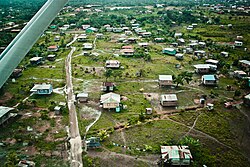 Aerial view of city | |
 Flag  Seal | |
 Bilwi Location in Nicaragua | |
| Coordinates: 14°01′42″N 83°22′58″W / 14.02833°N 83.38278°W | |
| Country | |
| Region | |
| Seat | Regional Council |
| Area | |
| • Municipality | 2,311 sq mi (5,985 km2) |
| Population (2020 estimate)[1] | |
| • Municipality | 127,181 |
| • Density | 55/sq mi (21/km2) |
| • Urban | 80,101 |
| Time zone | UTC-6 (Central Time) |
| • Summer (DST) | UTC-6 (No DST) |
| Climate | Am |


Bilwi, formerly known as Bragman’s Bluff, is a city and a municipality in Nicaragua. It is the capital of the North Caribbean Coast Autonomous Region. The name Bilwi means ‘Snake Leaf’ in Mayangna.
The municipality and the entire region are indigenous lands. The city of Bilwi borders the Community of Ten Communities.
History[]
In April 1905, the governments of Nicaragua and England signed the Harrison-Altamirano Treaty, the essence of which is the recognition by England of the sovereignty of Nicaragua over the territory of the Miskito Reserve, and the commitment of the Nicaraguan State to a series of concessions that offer a guarantee of survival for the inhabitants of it. These guarantees were, among others, exemption from military service for a specified period, land concessions, and others.
In 1921, the Bragman's Bluff Lumber Company signed a contract with the Karatá community, granting them 80,000 acres of land for the exploitation of pine trees. As a result of the activities and infrastructures created by the company, many current indigenous communities emerged as such. Subsequently, the community of Lamlaya became a door for the entry and exit of the exploitation of wealth from the interior of the region to Bilwi.
Parallel to this flourishing, the village of Bilwi, separated from the Bragmans facilities by a fence, expanded and developed according to the dynamics that this company generated. By 1925 there were 51 houses.
The requirements of qualified resources for the execution of more complex tasks in the processing of pine derivatives, motivated Bragman's to hire personnel from other countries, mainly from the Caribbean. This explains the diversity of ethnic groups that characterized and continues to typify the population of the municipality.
Bragman's presence in the area lasted ten years. On April 15, 1929, Bilwi was elevated to the rank of municipality. Later, by Legislative Decree, the municipal seat adopted the name of Bilwi.[2]
Hurricane Felix hit Bilwi on September 4, 2007, killing about 100 people.[3] Hurricane Eta hit the city on November 3, 2020, causing extensive damage.[4] 2 weeks later, on November 16, 2020, Hurricane Iota hit the city as a strong Category 4.
Education[]
The University of the Autonomous Regions of the Nicaraguan Caribbean Coast (URACCAN) has a campus in Bilwi, as well as in several other locations in the North Caribbean Coast Autonomous Region and the South Caribbean Coast Autonomous Region.
Climate[]
Bilwi has tropical monsoon climate (Köppen climate classification Am) with significant precipitation year round, and a short dry season in March and April. Even so, these months see an average precipitation of 48 millimetres (2 in) and 54 millimetres (2 in).[5] The average temperature ranges from a low of 24.5 °C (76.1 °F) in February to 27.8 °C (82.0 °F) in May.[5] The average annual precipitation is 2,799 millimetres (110 in) with 198 days with measureable rainfall.[5]
| hideClimate data for Puerto Cabezas, Nicaragua | |||||||||||||
|---|---|---|---|---|---|---|---|---|---|---|---|---|---|
| Month | Jan | Feb | Mar | Apr | May | Jun | Jul | Aug | Sep | Oct | Nov | Dec | Year |
| Average high °C (°F) | 29.7 (85.5) |
29.7 (85.5) |
30.5 (86.9) |
31.3 (88.3) |
31.8 (89.2) |
31.4 (88.5) |
30.8 (87.4) |
31.2 (88.2) |
31.2 (88.2) |
31.6 (88.9) |
30.8 (87.4) |
29.7 (85.5) |
30.8 (87.5) |
| Daily mean °C (°F) | 25.0 (77.0) |
24.5 (76.1) |
26.5 (79.7) |
27.2 (81.0) |
27.8 (82.0) |
27.5 (81.5) |
27.1 (80.8) |
27.1 (80.8) |
27.0 (80.6) |
26.3 (79.3) |
25.8 (78.4) |
25.4 (77.7) |
26.4 (79.6) |
| Average low °C (°F) | 18.8 (65.8) |
18.6 (65.5) |
19.8 (67.6) |
20.9 (69.6) |
21.8 (71.2) |
22.0 (71.6) |
21.9 (71.4) |
22.0 (71.6) |
22.2 (72.0) |
21.6 (70.9) |
20.8 (69.4) |
19.3 (66.7) |
20.8 (69.4) |
| Average rainfall mm (inches) | 148 (5.8) |
83 (3.3) |
48 (1.9) |
54 (2.1) |
183 (7.2) |
378 (14.9) |
414 (16.3) |
370 (14.6) |
303 (11.9) |
338 (13.3) |
278 (10.9) |
202 (8.0) |
2,799 (110.2) |
| Average rainy days (≥ 1.0 mm) | 16 | 11 | 7 | 8 | 12 | 20 | 23 | 22 | 20 | 20 | 19 | 20 | 198 |
| Source: Hong Kong Observatory[5] | |||||||||||||
International relations[]
Twin towns – Sister cities[]
Bilwi is sister city to:
|
Bilwi has a "sistership" link with Manchester.[6]
See also[]
References[]
| Wikivoyage has a travel guide for Bilwi. |
| Wikimedia Commons has media related to Puerto Cabezas. |
- ^ Citypopulation.de Population of departments and municipalities in Nicaragua
- ^ "Bilwi | Observatorio de la Autonomía Regional Multiétnica". observatorio.uraccan.edu.ni. Retrieved 2021-06-11.
- ^ AFP news Archived 2007-12-09 at the Wayback Machine
- ^ Reuters (November 3, 2020). "Hurricane Eta pounds Nicaragua as Category 4 storm". cnbc.com. CNBC. Retrieved November 3, 2020.
- ^ Jump up to: a b c d "Climatological Information for Puerto Cabezas, Nicaragua". Hong Kong Observatory. Archived from the original on March 22, 2013. Retrieved December 6, 2012.
- ^ "International networks and partnerships". Manchester City Council. Archived from the original on 4 April 2012. Retrieved 17 June 2012.
| show Authority control |
|---|
Coordinates: 14°01′41″N 83°22′51″W / 14.02807°N 83.380791°W
- Municipalities of the North Caribbean Coast Autonomous Region
- North Caribbean Coast Autonomous Region