Blackwaterfoot
Blackwaterfoot
| |
|---|---|
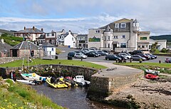 Village centre with tiny harbour | |
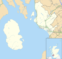 Blackwaterfoot Location within North Ayrshire | |
| OS grid reference | NR895281 |
| Civil parish |
|
| Council area | |
| Lieutenancy area | |
| Country | Scotland |
| Sovereign state | United Kingdom |
| Post town | ISLE OF ARRAN |
| Postcode district | KA27 |
| Dialling code | 01770 |
| Police | Scotland |
| Fire | Scottish |
| Ambulance | Scottish |
| UK Parliament | |
| Scottish Parliament | |

Blackwaterfoot (Scottish Gaelic: Bun na Uisge Dubh lit. 'foot of the black water') is a village on the Isle of Arran in the Firth of Clyde, Scotland. The village is within the parish of Kilmory.[1] It is located in the Shiskine valley in the south-west of the island. It is one of the smaller villages of Arran and home to one of Europe's two 12-hole golf courses. A short walk from Blackwaterfoot is Drumadoon Point, home to the largest Iron Age fort on Arran. Further North is the King's Cave, reputed to be a hiding place of Robert the Bruce.

View of Blackwaterfoot from the south
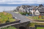
Village centre with Harbour Shop, looking east toward Kintyre


References[]
- ^ "Details of Blackwaterfoot". Scottish Places. Retrieved 31 December 2014.
External links[]
| Wikimedia Commons has media related to Blackwaterfoot. |
| Main villages |  | |
|---|---|---|
| Smaller villages and settlements | ||
| Mountains and hills | ||
| History |
| |
| Environment | ||
| Economy | ||
| Surrounding islands | ||
This North Ayrshire location article is a stub. You can help Wikipedia by . |
Categories:
- Villages in the Isle of Arran
- North Ayrshire geography stubs