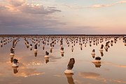
Bogdo-Baskunchak Nature Reserve
| Bogdinsko-Baskunchakski Nature Reserve | |
|---|---|
| Russian: Богдинско-Баскунчакский заповедник | |
 Big Bogdo Mountain slope, with salt lake in distance | |
 Location of Reserve | |
| Location | Astrakhan Oblast |
| Nearest city | Akhtubinsk |
| Coordinates | 48°12′42″N 46°52′50″E / 48.21167°N 46.88056°ECoordinates: 48°12′42″N 46°52′50″E / 48.21167°N 46.88056°E |
| Area | 18,780 hectares (46,406 acres; 73 sq mi) |
| Established | 1997 |
| Governing body | Ministry of Natural Resources and Environment (Russia) |
| Website | http://www.bogdozap.ru/ |
Bogdinsko-Baskunchakski Nature Reserve (Russian: Богдинско-Баскунчакский) (also Bogdinsko-Baskunchaksky) is a Russian 'zapovednik' (strict nature reserve) in a semi-arid area around two notable features: Lake Baskunchak, Russia's largest undrained salt lake, and Big Bogdo Mountain, the highest point (at 147 meters) in the Caspian Depression and home to the "singing rocks". It is about halfway between Volgograd and Astrakhan, placing it about 200 km north of the Volga River Delta, where the river enters the Caspian Sea from the northwest. About 20 km east of the lake is the border with Kazakhstan. Baskunchak has been a source of salt to Russia for centuries. The reserve is an important site on the bird migration route between northern Siberia and wintering regions. The reserve is situated in the Akhtubinsky District of Astrakhan Oblast.[1][2]
Topography[]
The reserve lies in the trough of the Caspian Depression, just east of the Volga's present main floodplain. The boundaries wrap around the north, east and south shores of the lake, and the mountain is in a separate sector just south of the lake. The main features - the shores of Lake Baskunchak and Big Bogdo Mountain, are seated about 25 meters below sea level. The top of Big Bogdo is 130 meters above the terrain. The hill itself is a karst (limestone) formation with over 30 caves. It is growing approximately 1 mm in height each year due to the pressure of the underlying salt dome.[1]
Red Rocks at the foot of Bolshoye Bogdo (Big Bogdo) Mountain

"Singing Rock"; air flow over limestone formations causes unusual sounds

Climate and Ecoregion[]
Bogdinsko-Baskunchakski is located in the northwest of the Caspian lowland desert ecoregion. This region, on the north and northeast shores of the Caspian Sea, is characterized by sand dunes and ridges, salt soil, clay deserts (takyrs), and in places solonchaks (shors) or salt pans of 30–40 cm thickness devoid of vegetation. The sedimentary landscape is recently exposed lake bed (during the Tertiary the Caspian Basin was connected across the Black Sea to the Mediterranean.)[3]
The climate of Bogdinsko-Baskunchakski is Humid continental climate, cool summer (Köppen climate classification (Dwb)). This climate is characterized by high variation in temperature, both daily and seasonally; with dry winters and cool summers.[4][5] Average annual temperature is 15.4 C. Annual precipitation averages 150 mm.[3]
Flora and fauna[]
Plant life is sparse but features highly specialized halophytes (salt-tolerant plants). Big Bogdo Mountain is the only habitat in Russia of the squeaky gecko (Alsophylax pipiens).[1] It is also a site for the endangered Russian Steppe eagle.

Ecotourism[]
Big Bogdo mountain is considered a sacred site by some Buddhists, and there is one trail open to visitors - a 2.5 km hike to Big Bogdo ("Trail Legends of the Holy Mountain") with an observation deck and informational placards. There is also driving tour escorted by reserve officers to the shore of the lake. Passes must be obtained from the reserve office in Akhtubinsk. As a strict nature reserve in a sensitive environment, however, most of the Reserve is closed to the general public and access is strictly guarded by patrols. Scientists and those with 'environmental education' purposes can make arrangements with reserve management for visits.[2]
See also[]
- List of Russian Nature Reserves (class 1a 'zapovedniks')
References[]
- ^ Jump up to: a b c "Bogdinsko-Baskunchakski Zapovednik (Official Site)" (in Russian). Ministry of Natural Resources and Environment (Russia). Retrieved January 21, 2016.
- ^ Jump up to: a b "Bogdinsko-Baskunchakski Zapovednik" (in Russian). Ministry of Natural Resources and Environment (Russia). Retrieved January 21, 2016.
- ^ Jump up to: a b "Caspian desert lowland". Encyclopedia of the Earth. Archived from the original on August 9, 2014. Retrieved February 5, 2016.
- ^ Kottek, M., J. Grieser, C. Beck, B. Rudolf, and F. Rubel, 2006. "World Map of Koppen-Geiger Climate Classification Updated" (PDF). Gebrüder Borntraeger 2006. Retrieved September 14, 2019.CS1 maint: multiple names: authors list (link)
- ^ "Dataset - Koppen climate classifications". World Bank. Retrieved September 14, 2019.
External links[]
| Wikimedia Commons has media related to Bogdo-Baskunchak Nature Reserve. |
- Nature reserves in Russia
- 1997 establishments in Russia
- Protected areas established in 1997
- Geography of Astrakhan Oblast


