Bohostice
show This article may be expanded with text translated from the corresponding article in Czech. (July 2009) Click [show] for important translation instructions. |
Bohostice | |
|---|---|
Municipality and village | |
 | |
 Flag  Coat of arms | |
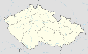 Bohostice Location in the Czech Republic | |
| Coordinates: 49°36′N 14°09′E / 49.600°N 14.150°ECoordinates: 49°36′N 14°09′E / 49.600°N 14.150°E | |
| Country | |
| Region | Central Bohemian Region |
| District | Příbram District |
| Government | |
| • Starostka | Růžena Králová |
| Population (2018) | |
| • Total | 189 |
| Time zone | UTC+1 (CET) |
| • Summer (DST) | UTC+2 (CEST) |
| Website | www |

Bohostice is a village and municipality in Příbram District in the Central Bohemian Region of the Czech Republic.
Landscape[]
The local district of about 21 km² is mostly wooded and hilly, with the highest point at 544 m and lowest at 350 m at the level of the reservoir. Located some 2 km from the left bank of the Orlik artificial lake, it is an important recreational locality. There are some camp sites and cottage settlements in the cadastre of the village. Some 40 to 50 m below the lake surface still stand the remains of the church of St. Stephen and the flooded village Těchnice.
History and landmarks[]
The first written mention of the village dates from 1386 . Having no significant industry and no railway connection, the main economy was farming and forestry until the second half of the 20th century, when the reservoir coastline became popular as a recreational area.
- Empire chateau
- houses from 1954–1956 for the inhabitants of the villages flooded by the Orlik reservoir
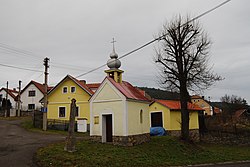
- village chapel against the castle
- cross in front of the chapel
- natural monument (SAC) Bohostice with the occurrence of dusky large blue, pronounced in 2013
- Jewish cemetery in the fields to southwest on the Chlumec hill with some 150 tombs
References[]
- This article was initially translated from the Czech Wikipedia and expanded accordingly.
| Wikimedia Commons has media related to Bohostice. |
| Authority control: National libraries |
|---|
- Municipality articles needing translation from Czech Wikipedia
- Populated places in Příbram District
- Villages in Příbram District
- Příbram geography stubs