Bollenbach (Argen)
This article does not cite any sources. (June 2019) |
| Bollenbach | |
|---|---|
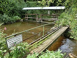 Weir northeast of Laimnau | |
| Location | |
| Location | Germany |
| Reference no. | DE: 215292 |
| Physical characteristics | |
| Source | |
| • location | Near Obereisenbach |
| • coordinates | 47°41′23″N 9°38′39″E / 47.68972°N 9.64417°ECoordinates: 47°41′23″N 9°38′39″E / 47.68972°N 9.64417°E |
| • elevation | around 510 m above sea level (NN) |
| Mouth | |
• location | Near into the Argen |
• coordinates | 47°38′04″N 9°37′44″E / 47.63444°N 9.62889°E |
• elevation | around 431 m above sea level (NN) |
| Length | 7.8 km |
| Basin features | |
| Progression | Argen→ Lake Constance→ Rhine→ North Sea |

The Bollenbach is a roughly 7.8-kilometre-long stream in the German state of Baden-Württemberg within the county of Bodenseekreis. It is a right-hand tributary of the Argen.
Course[]
The Bollenbach rises north of the Tettnang village of Obereisenbach from several springs that lie within the forest of Arlenholz. Thereafter it flows, canalized, in a southerly direction through countryside used for agriculture. After , a village on the Upper Swabian Baroque Route, it passes through the Bollen woods. Here its course is more original. It continues southwards, running past Wiesertsweiler and through the village of , where it finally empties into the Argen.
Tributaries[]
From its source to its mouth the Bollenbach picks up the waters of many unnamed streams as well as the following tributaries:
- Flockenbach (l), south of Tannau
- Kreuzweiherbach (l), near Wiesertsweiler
See also[]
- Tributaries of the Argen
- Rivers of Baden-Württemberg
- Rivers of Germany