Bondhusbreen
| Bondhusbreen | |
|---|---|
 | |
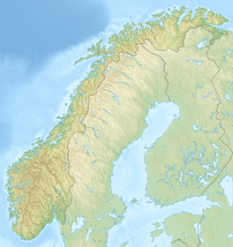
 Location of the glacier | |
| Location | Vestland, Norway |
| Coordinates | 60°03′24″N 06°18′50″E / 60.05667°N 6.31389°ECoordinates: 60°03′24″N 06°18′50″E / 60.05667°N 6.31389°E |
| Length | 4 km (2.5 mi) |

The Bondhusbreen is a glacier in Kvinnherad Municipality in Vestland county, Norway. The glacier is an offshoot of the vast Folgefonna glacier, and it lies inside the Folgefonna National Park. The glacier has a length of around 4 kilometres (2.5 mi) and a height difference of about 1,100 metres (3,600 ft) from its highest to its lowest points.

Lake Bondhus, glacier Bondhusbreen in the background as a part of the Folgefonna Glacier
The glacier is located at the end of a small valley (named Bondhusdalen), just south of the village of Sundal on the shore of the Maurangsfjorden. Water draining under the glacier is caught through a tunnel and exploited in the Mauranger Hydroelectric Power Station.[1]
See also[]
References[]
- ^ Henriksen, Petter (ed.). "Bondhusbreen". Store norske leksikon (in Norwegian). Oslo: Kunnskapsforlaget. Retrieved 27 August 2011.
| Authority control |
|
|---|
This Vestland location article is a stub. You can help Wikipedia by . |
Categories:
- Glaciers of Vestland
- Kvinnherad
- Vestland geography stubs