Bongdam
Bongdam
봉담 峰潭 | |
|---|---|
| Korean transcription(s) | |
| • Hangul | 봉담읍 |
| • Hanja | 峰潭邑 |
| • Revised Romanization | Bongdam-eup |
| • McCune-Reischauer | Pongdam-ŭp |
 Bongdam Location in South Korea | |
| Coordinates: 37°13′12″N 126°56′58″E / 37.22000°N 126.94944°E | |
| Country | |
| Region | Sudogwon |
| Administrative divisions | 16 ri |
| Area | |
| • Total | 42.703 km2 (16.488 sq mi) |
| Population (January 2011) | |
| • Total | 67,694 |
| • Density | 1,585.2/km2 (4,106/sq mi) |
| • Dialect | Seoul |

Bongdam is a town in the city of Hwaseong in South Korea. Covering over 4000 hectares, the town is the focus of a planned community, primarily as a commuter town for the bordering city of Suwon.
History[]
- April 1, 1914: Suwon-gun (수원군)'s Sambong-myeon (삼봉면 - 三峰面) and Galdam-myeon (갈담면 - 葛潭面) were combined, forming Bongdam-myeon (봉담면 - 峰潭面), a town of 15 villages.
- August 14, 1949: As Suwon-eup was raised in status to Suwon-bu, the remainder of Suwon-gun was renamed Hwaseong-gun. (Suwon-bu became a city soon afterwards.)
- February 15, 1983: Bibong-myeon's village of Sanggi-ri left Bibong-myeon and became part of Bongdam-myeon, completing the 16 villages which remain in Bongdam today.
- May 1992: Bongdam-myeon's council office moved from 31-3 Sang-ri to the nearby newly constructed facility at 27-1 Sang-ri.
- April 1, 1998: Bongdam's status was raised from myeon to eup.
- March 21, 2001: Hwaseong's status was raised from gun (county) to si (city).
- March 20, 2008: Much of the housing in Donghwa-ri was cleared for a new housing development.
Geography[]
Bongdam is bounded to the north-west by the hills of Sambongsan (삼봉산 - 三峰山: 271m) and Taehaengsan (태행산 - 太行山: 266m), to the west by Geocheon Reservoir and Geondalsan (건달산 - 建達山: 328m), to the south-west by Deogu Reservoir and Cheolmasan (철마산 - 鐵馬山: 123m), to the south-east by Seobongsan (서봉산 - 棲鳳山: 250.3m), to the east by Taebongsan (태봉산 - 太鳳山: 224m) and Botong Reservoir, and to the north-east by Gogeumsan (고금산 - 古琴山: 87m) and the city of Suwon. No major streams pass through the town, though its plain is drained in entirety to Sihwa.
Demographics[]
Bongdam's population is currently increasing, and this is expected to continue as further housing developments are planned. The foreign population stands at 4.6%, approximately double the national average.[1]
Administrative divisions[]
Bongdam is divided into 16 ri (villages):
- Buncheon-ri (분천리)
- Dangha-ri (당하리)
- Deogu-ri (덕우리)
- Deok-ri (덕리)
- Donghwa-ri (동화리)
- Hagadeung-ri (하가등리)
- Maha-ri (마하리)
- Nae-ri (내리)
- Sanggi-ri (상기리)
- Sang-ri (상리)
- Segok-ri (세곡리)
- Sugi-ri (수기리)
- Suyeong-ri (수영리)
- Wangnim-ri (왕림리)
- Wau-ri (와우리)
- Yu-ri (유리)
Education[]
Bongdam is home to six institutes of higher education: the University of Suwon, Hyupsung University, Suwon Catholic University, the Haeran Campus of Suwon Women's University, Jangan College, and Korea National College of Agriculture and Fisheries. The town also has a high school, three middle schools and seven primary schools.[2]
Transport[]
Rail[]
Trains on the former Suin Line used to pass through Suyeong-ri in the far north of Bongdam. The Suin Line is currently being reconstructed and will form part of the Seoul Subway network. It is planned for a station named Bongdam, two stops from Suwon, to be operating by 2012, though this station will be just outside Bongdam, in Suwon's Omokcheon-dong. Also, all KTX trains pass through Bongdam, though the town does not have a station on this line.
Road[]
Bongdam has an interchange on combined motorways 17 and 400.
Culture[]
The Baekje tombs in Maha-ri and other important graves - those of Lee Gon (이곤) in Sang-ri, and Buncheon-ri's tombs of Seo Geojeong (서거정) and Choi Rubaek (최루백), are among the oldest significant remains in Bongdam. There are also two older Buddhist temples: Beopheungsa in Sugi-ri, Bogwangsa in Wangnim-ri.
Gallery[]
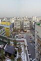
Bongdam's central square

Road past Bongdam Centre
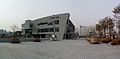
Hwaseong Sports Centre

Lake by Bongdam Council Office
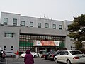
Bongdam Council Office

Bongdam Public Library


References[]
- ^ "인구현황 Inguhyeonhwang". Hwaseong City Council. Archived from the original on 2012-08-02. Retrieved 2011-02-15.
- ^ "화성시청봉담읍사무소우리마을소개 Hwaseongsicheong Bongdameupsamuso Urimaeulsogae". Hwaseong City Council. Archived from the original on 2013-02-22. Retrieved 2011-02-14.
External links[]
Coordinates: 37°13′12″N 126°56′58″E / 37.22000°N 126.94944°E
- Towns and townships in Gyeonggi Province
- Hwaseong, Gyeonggi