Bonny, Nigeria
Bonny
Ibani | |
|---|---|
Town | |
 Bonny panoramic | |
 Bonny | |
| Coordinates: 4°26′N 7°10′E / 4.433°N 7.167°E | |
| Country | |
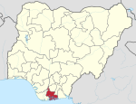
| State | Rivers State |
| Government | |
| • Local Government Chairman | Anengi Barasua (PDP) |
| • Deputy Local Government Chairman | Vacant |
| • Local Government Council | Ward 1: Ibienimi Geoffrey Allison (PDP) Ward 2: Kelvin Pepple (PDP) Ward 3: Fiberesima Pepple (PDP) Ward 4: Dipinye Nelson Jumbo (PDP) Ward 5: Ene Tomintoul (PDP) Ward 6: Erefagha Allaputa (PDP) Ward 7: Ibaningo Larry (PDP) Ward 8: Daniel Green (PDP) Ward 9: Godswill Pepple (PDP) Ward 10: Kingsley Tamy Jumbo (PDP) Ward 11: Patience Anetor Johnson Green (PDP) Ward 12: Marvellous Briston (PDP) |
| Area | |
| • Total | 249.27 sq mi (645.60 km2) |
| Population (2006) | |
| • Total | 214,983[1] |
| Time zone | UTC+1 (WAT) |

Bonny (originally Ibani)[2] is a traditional, coastal town and a Local Government Area in Rivers State in southern Nigeria, on the Bight of Bonny. It is also the capital of the Kingdom of Bonny. Traditionally (especially between the 15th and 19th centuries) it was a major trading post of the eastern Delta, a practice which witnessed the sale of slaves, mostly from Igbo descent.[3] Bonny Island is a major export point for oil.[4]
The region produces a type of crude oil known as Bonny Light oil. Much of the oil extracted onshore in Rivers State is piped to Bonny for export. It has the biggest LNG Gas Plant in Nigeria with six (6) trains. Currently the Federal Government of Nigeria has set plans for the construction of the 7th train of the NLNG to boost its gas production in anticipation of dominating the African market.
Bonny has a bridge being constructed from Bodo in Gokana LGA to enable land transportation. A deep seaport is underway as a Corporate Social Responsibility project from CCECC.
Kingdom of Bonny[]
The Kingdom of Bonny was a sovereign state in the Niger Delta.
The kingdom, comprising virgin lands and territorial areas, was founded before or about AD 1400 by Okpara Ndoli. From these leaders and the entire founding generation of the kingdom evolved the lineage/ward/house system of governance that is currently used to administer the state. The“Amanyanabo”, or monarch (lit. owner of the land);), presided over a chieftaincy system composed of the "Ase-Alapu" (or high chiefs of royal blood) and the “Amadapu” (or district heads).
The Kingdom of Bonny was powerful beginning in the 15th century with the advent of the Portuguese and the following Atlantic slave trade. In the 19th century, it came under increasing pressure from the British to end the trade. It collapsed in the subsequent Bonny civil war of 1869.[5] A remnant of it continues to exist as a part of the contemporary aristocratic structure of Nigeria. the people of Bonny are still in existence and the town is still occupied with people of different tribes.
See also[]
References[]
- ^ "population at LGAs in geohive.com". Archived from the original on 2013-10-19. Retrieved 2013-04-07.
- ^ Dalby, Routledge (1971). African Language Review. Routledge. p. 251. ISBN 0-7146-2690-2.
- ^ "Bonny". Britannica Online Encyclopedia. Retrieved 2009-01-28.
- ^ Frynas, Jedrzej Georg (2000). Oil in Nigeria: Community Rights and Corporate Dominance in Conflict. LIT Verlag Berlin-Hamburg-Münster. p. 79. ISBN 3-8258-3921-4.
- ^ Alagoa, E. J. (1971). Nineteenth Century Revolutions in the Eastern Delta states and Calabar. Journal of Historical Society of Nigeria 5(4). pp. 565–570.
External links[]
| Look up bonny in Wiktionary, the free dictionary. |
- Bonny at Encyclopædia Britannica
- Bonny at Encyclopedia.com
- King Jaja of Opobo at Black History Pages
Local government areas of Rivers State | ||
|---|---|---|
| LGAs |
|  |
Authority control | |
|---|---|
| General |
|
| National libraries | |
- Oil fields of Nigeria
- Towns in Rivers State
- Local Government Areas in Rivers State
- Populated coastal places in Rivers State