Borough of Stockton-on-Tees
Borough of Stockton-on-Tees
Stockton Borough | |
|---|---|
Unitary Authority Borough | |
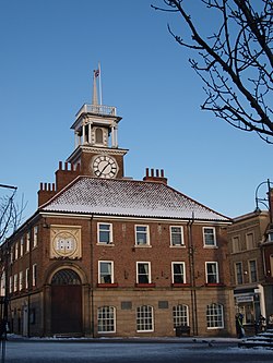 Stockton Town House | |
 Coat of Arms of Stockton-on-Tees | |
 the part of Stockton-on-Tees within County Durham | |
 the part of Stockton-on-Tees within North Yorkshire | |
| Sovereign state | United Kingdom |
| Country | England |
| Region | North East England |
| Combined authority | Tees Valley |
| Ceremonial county | Durham North Yorkshire |
| Admin. HQ | Stockton-on-Tees |
| Government | |
| • Type | Stockton-on-Tees Borough Council |
| • Leadership: | Leader & Cabinet |
| • Executive: | Labour |
| • Tees Valley Mayor | Ben Houchen |
| • Mayor | Councillor Kevin Faulks[1] |
| • MPs: | Alex Cunningham (L) Matt Vickers (C) |
| Area | |
| • Total | 79.2 sq mi (205.0 km2) |
| Area rank | 158th |
| Population (mid-2019 est.) | |
| • Total | 197,348 |
| • Rank | Ranked 95th |
| • Density | 2,500/sq mi (960/km2) |
| Time zone | UTC+0 (Greenwich Mean Time) |
| • Summer (DST) | UTC+1 (British Summer Time) |
| ONS code | 00EF (ONS) E06000004 (GSS) |
| Ethnicity | 97.2% White 1.7% S.Asian |
| Website | stockton.gov.uk |
The Borough of Stockton-on-Tees, commonly called Stockton Borough, is a local authority and borough in County Durham and North Yorkshire. It is part of the Tees Valley mayoralty in Northern England. The main town is Stockton, which lies on the north bank of the River Tees. In the 2011 census, the town and borough had a population of 82,880 and 191,600 respectively.[2] The majority of the borough's population is in the Teesside built-up area.
The borough is governed by the unitary authority of Stockton-on-Tees Borough Council, and the Mayor is Cllr Kevin Faulks.[1]
All River Tees bridges from Yarm Viaduct to Transporter Bridge are in the borough at least on one side, with the Borough of Middlesbrough to the south downstream. Teesside International Airport is shared between the borough and the Borough of Darlington.
Beside Stockton, the other town in the borough north of the Tees is Billingham. The largest towns south of the river are Ingleby Barwick, Thornaby-on-Tees and Yarm.
History[]
Municipal authority[]
Stockton previously held borough status as the Municipal Borough of Stockton-on-Tees in historic County Durham.
Loss of status[]
In 1968, the borough was merged into Teesside County Borough; this civil parish was a part of the unadministrative North Riding county until its abolition.
District authority[]
The town regained borough status on 1 April 1974 as a result of the Local Government Act 1972. It became a non-metropolitan district of the County of Cleveland, itself established at the same time. Multiple parishes and boroughs merged into Stockton's newly formed district borough:
- Teesside County Borough's area covering the former Stockton, Billingham and Thornaby municipal boroughs,
- Hilton, Ingleby Barwick, Kirklevington, Maltby, and Yarm parishes of the previous North Riding County-administrated Stokesley Rural District, and
- Part of the County Durham-administrated Stockton Rural District parishes.
Unitary authority[]

The borough became a unitary authority on 1 April 1996. It is ceremonially split between County Durham and the North Riding of Yorkshire, to the north and south of the Tees respectively. It is the only council in England to be split between two ceremonial counties. The former districts and boroughs of Durham now form the unitary authority of County Durham, so ceremonial County Durham now has four unitary authorities.
Council[]
The Borough has 26 wards with either one, two or three councillors representing each. There are 56 councillors in total. Following the May 2015 elections, the councillors are divided politically as follows:
- 32 Labour
- 13 Conservative
- 5 Ingleby Barwick Independent Society
- 3 Thornaby Independent Association
- 2 West Words
- 1 Liberal Democrats (UK)[3]
Economy[]
The Office for National Statistics has published a chart (pp. 240–253) of the trend of regional gross value of Hartlepool and Stockton-on-Tees (figures in Sterling [millions]).
| Year | Regional Gross Value Added4 | Agriculture1 | Industry2 | Services3 |
|---|---|---|---|---|
| 1995 | 2,804 | 9 | 1,443 | 1,352 |
| 2000 | 3,252 | 6 | 1,359 | 1,887 |
| 2003 | 3,364 | 6 | 1,037 | 2,320 |
^1 includes hunting and forestry.
^2 includes energy and construction.
^3 includes financial intermediation services indirectly measured.
^4 Components may not sum to totals due to rounding.
Local Nature Reserves[]
The council maintains a number of local nature reserves including Barwick Pond, Charlton's Pond, Greenvale, Hardwick Dene and Elm Tree Woods, Norton Grange Marsh, Quarry Wood (Eaglescliffe), and Stillington Forest Park.
References[]
- ^ Jump up to: a b "Former blast furnace worker becomes Stockton mayor". Northern Echo. Retrieved 2 August 2021.
- ^ "Table P07 2011 Census: Number of usual residents living in households and communal establishments, local authorities in England and Wales". 2011 Census, Population and Household Estimates for England and Wales. Office for National Statistics. Retrieved 17 July 2012.
- ^ "Councillors and Council Meeting Information (Egenda)". www.stockton.gov.uk. Archived from the original on 20 August 2009. Retrieved 2 July 2009.
External links[]
- Statistics about Stockton-on-Tees from the Office for National Statistics Census 2001
| show |
|---|


Coordinates: 54°33′N 1°20′W / 54.550°N 1.333°W

| Authority control |
|
|---|
- Borough of Stockton-on-Tees
- Unitary authority districts of England
- Places in the Tees Valley
- Local government in County Durham
- Local government districts of North Yorkshire
- Local government districts of North East England