Bottleneck Peak
| Bottleneck Peak | |
|---|---|
 | |
| Highest point | |
| Elevation | 6,235 ft (1,900 m)[1] |
| Prominence | 455 ft (139 m)[1] |
| Parent peak | Point 6403[1] |
| Isolation | 0.65 mi (1.05 km)[1] |
| Coordinates | 39°04′06″N 110°40′51″W / 39.0683°N 110.6809°WCoordinates: 39°04′06″N 110°40′51″W / 39.0683°N 110.6809°W[1] |
| Geography | |
 Bottleneck Peak Location in Utah | |
| Location | Emery County, Utah, U.S. |
| Parent range | San Rafael Swell Colorado Plateau |
| Topo map | USGS Bottleneck Peak |
| Geology | |
| Type of rock | sandstone |
| Climbing | |
| First ascent | June 23, 1973 by Jim Langdon[2] |
| Easiest route | class 5.11- climbing[1] |

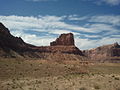
Bottleneck Peak is a natural monolith located on the eastern side of in the Utah San Rafael Swell wilderness area.[3] It is situated 2.1 miles (3.4 km) northwest of Window Blind Peak. Precipitation runoff from this feature drains north into the San Rafael River.
Gallery[]

Bottleneck Peak and San Rafael River


References[]
- ^ a b c d e f "Bottleneck Peak - 6,235' UT". listsofjohn.com. Retrieved 2020-11-20.
- ^ "First Ascent Timeline". DesertTowersBook.
- ^ "Bottleneck Peak". Geographic Names Information System. United States Geological Survey. Retrieved 2020-11-20.
External links[]
- Weather forecast: Bottleneck Peak
- Bottleneck Peak rock climbing: Mountainproject.com
This article about a location in Utah is a stub. You can help Wikipedia by . |
Categories:
- Monoliths of the United States
- Rock formations of Utah
- Landforms of Emery County, Utah
- Utah geography stubs