Bourn Airfield
Bourn Airport | |||||||||||||||
|---|---|---|---|---|---|---|---|---|---|---|---|---|---|---|---|
| Summary | |||||||||||||||
| Airport type | Private | ||||||||||||||
| Operator | Rural Flying Corps | ||||||||||||||
| Location | Cambridge | ||||||||||||||
| Elevation AMSL | 226 ft / 69 m | ||||||||||||||
| Coordinates | 52°12′38″N 000°02′33″W / 52.21056°N 0.04250°WCoordinates: 52°12′38″N 000°02′33″W / 52.21056°N 0.04250°W | ||||||||||||||
| Website | www.rfcbourn.flyer.co.uk | ||||||||||||||
| Map | |||||||||||||||
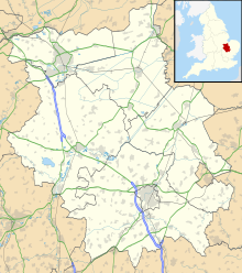 EGSN Location in Cambridgeshire | |||||||||||||||
| Runways | |||||||||||||||
| |||||||||||||||

Bourn Airport (IATA: n/a, ICAO: EGSN) is located 7 NM (13 km; 8.1 mi) west of Cambridge, Cambridgeshire, England. The airfield was originally constructed during World War II as RAF Bourn and was principally used as a base for heavy bombers - Wellingtons, Stirlings and Lancasters were all based at Bourn at one time or another. Nowadays,[when?] the airfield is used for recreational use, and flight training has been provided by the Bourn Rural Flying Corps for in excess of 30 years.
As of 2021 the site is owned by Countryside Plc, who intend to build 3500 houses.[2][3][4]
References[]
- ^ Bourn - EGSN entry from 2004 hosted at Rural Flying Corps site
- ^ "Bourn Airfield". www.bournairfield.co.uk. Retrieved 30 January 2022.
- ^ "Bourn Airfield: Thousands of new homes set for World War Two site". BBC News. 19 February 2021.
- ^ "Countryside gets green light for mixed-use community at Bourn Airfield | Countryside Properties". www.countrysideproperties.com.
External links[]
This article about an airport in the United Kingdom is a stub. You can help Wikipedia by . |
Categories:
- Airports in England
- Transport in Cambridgeshire
- Airports in the East of England
- United Kingdom airport stubs