Bourne, Lincolnshire
| Bourne | |
|---|---|
 Bourne town centre | |
 Bourne Location within Lincolnshire | |
| Population | 13,961 [1] |
| OS grid reference | TF094202 |
| • London | 90 mi (140 km) S |
| Civil parish |
|
| District | |
| Shire county | |
| Region | |
| Country | England |
| Sovereign state | United Kingdom |
| Post town | BOURNE |
| Postcode district | PE10 |
| Dialling code | 01778 |
| Police | Lincolnshire |
| Fire | Lincolnshire |
| Ambulance | East Midlands |
| UK Parliament | |

Bourne is a market town and civil parish in the South Kesteven district of Lincolnshire, England. It lies on the eastern slopes of the limestone Kesteven Uplands and the western edge of the Fens,[2] 11 miles (18 km) north-east of Stamford, 12 miles (19 km) west of Spalding and 17 miles (27 km) north of Peterborough. The population at the 2011 census was 14,456.[3] A 2019 estimate put it at 16,780.[4]
History[]

The Ancient Woodland of Bourne Woods is still extant, although much reduced. It originally formed part of the ancient Forest of Kesteven and is now managed by the Forestry Commission.
The earliest documentary reference to Brunna, meaning stream, is from a document of 960, and the town appeared in the Domesday Book of 1086 as Brune.[2]
Bourne Abbey, (charter 1138), formerly held and maintained land in Bourne and other parishes. In later times this was known as the manor of Bourne Abbots. Whether the canons knew that name is less clear. The estate was given by the Abbey's founder, Baldwin fitz Gilbert de Clare, son of Gilbert fitz Richard, and later benefactors. The abbey was established under the Arrouaisian order. Its fundamental rule was that of St Augustine and as time went on, it came to be regarded as Augustinian. The Ormulum, an important Middle English Biblical gloss, was probably written in the abbey in around 1175.
Bourne Castle was built on land that is now the Wellhead Gardens in South Street.[5][6][7]

Bourne was an important junction on the Victorian railway system, but all such connections were severed after the Second World War (see Rail heading). The business stimulus it brought caused major development of the town, and many of the buildings around the medieval street plan were rebuilt, or at least refaced. Improved communications allowed a bottled water industry to develop, and to provide coal deliveries for the town's gas works.
The then local authority, Bourne Urban District Council, was very active in the interests of the town, taking over the gas works and the local watercress beds at times of financial difficulty and running them as commercial activities. Large numbers of good quality council houses were built by them in the early 20th century.
Bourne sent many men to both world wars, but was otherwise only lightly affected. During the Second World War, in May 1941, a German bomber was shot down and crashed onto the Butcher's Arms public house in Eastgate. The landlord and his wife and eight soldiers billetted across the road were killed,[8] as were the bomber's crew. In a separate incident, a number of bombs were dropped on the Hereward Camp approved school.[citation needed]
The town[]

The town is located on a Roman road now known as King Street. It was built around some natural springs, hence the name "Bourne" (or "Bourn"). which derives from the Anglo-Saxon burna or burne meaning "water" or "stream".[2] It lies on the intersection of two main roads: the A15 and the A151. The civil parish includes the main township along with the hamlets of Cawthorpe, Dyke and Twenty.[9] In former years Austerby was regarded as a separate settlement, with its own shops and street plan, but is now an area of Bourne known as The Austerby.(52°45′47″N 0°22′12″W / 52.763°N 0.370°W).[10]

The ecclesiastical parish of Bourne is part of the Beltisloe Deanery of the Diocese of Lincoln and based at the Abbey Church of St Peter and St Paul, in Church Walk.[11] Other religious congregations in the town include Methodist, Baptist, United Reformed and Roman Catholic churches.
The town's economy was based on rural industries until the railway opened up a market for bottled mineral water. It is still focused mainly on agriculture and food preparation for supermarkets.[citation needed] The population was 14,456 in the 2011 Census.
Much of Bourne's 19th-century affluence came from the corn-trade boom that followed the mechanisation of fen drainage. The production of wheat is still important. In the 21st century, hydroponic food production plants have been built on the edge of the fen.[citation needed]
Governance[]

Lincolnshire County Council[]
Bourne has two County Council divisions:
- Bourne North and Morton
- Bourne South and Thurlby
South Kesteven District Council[]
This section needs to be updated. (May 2015) |
Bourne has three District Council wards, two having two councillors and the new ward, Austerby, having three councillors.
- Bourne East
- Bourne West
- Bourne Austerby
Bourne Town Council[]

Bourne Town Council has two wards which are identical to the South Kesteven District Council wards. Bourne East elects seven councillors to the town council and Bourne West eight.
From 1899 to 1974, Bourne had an urban district council in the former Parts of Kesteven. Under the Local Government Act 1972, Bourne UDC was dissolved into the newly formed South Kesteven district. Urban districts which disappeared in this way formed successor parishes and were given a dispensation to call their "parish" councils "town" councils, with their chairs to be known as mayor. These town councils were allowed to adopt the coat of arms granted to the former UDC.
A Bourne Rural District also existed from 1894 to 1931, when it was abolished to form part of a larger South Kesteven Rural District. The parish of Bourne had formed part of Bourne RD from 1894 to 1899. South Kesteven RDC had its own coat of arms, which disappeared along with that of Kesteven in 1974.
International links[]
Since October 1989, Bourne has been twinned with Doudeville, Seine Maritime, France.
Drainage[]
Parts of west Bourne are drained by one of two internal drainage boards, The Black Sluice IDB[12] and the Welland and Deepings IDB.[13]
Many houses in Bourne pay additional drainage rates to these authorities. Details of the designated flood risk areas can be found on a number of government web sites.[14][15]
Education[]
- Bourne Abbey Church of England Academy (primary)
- Bourne Grammar School (secondary, sixth form)
- Bourne Academy formerly Robert Manning Technology College (secondary, sixth form)
- (primary)
- Willoughby School (Special Educational needs)
- Bourne Elsea Park Primary Academy (primary)
Communications[]
Road[]

Bourne Market Place is at the crossroads of the A15 road and the B1193.
Bus[]
There is a bus station at the top of North Street. The town's bus services are provided by the family-owned company Delaine. There is a daily long-distance coach between Grimsby and London Victoria, which stops at Bourne bus station.
Railways[]
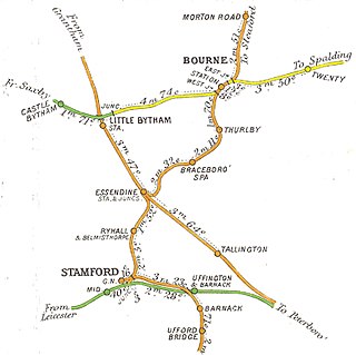
The first local railway was the Earl of Ancaster's estate railway, which ran from the East Coast Main Line at Little Bytham, through the Grimsthorpe estate to Edenham.[16]
Later Bourne had a railway station served by the Bourn and Essendine Railway (old spelling) line from Essendine[17] to Sleaford and by the Midland and Great Northern Joint Railway (M&GN) connecting the Midlands to East Anglia.[18] Timetabled passenger services on both lines had ceased by the end of February 1959 and the lines were closed to occasional use by the Beeching Axe. With the exception of Red Hall, the main station buildings were demolished in 1964, a year after the Beeching Report. The main goods shed, of wooden construction, survived. The mechanism of the locomotive turntable is now in use in the Wansford depot of the Nene Valley Railway.[citation needed]
Shipping[]
The Bourne-Morton Canal or Bourne Old Eau connected the town to the sea in Roman times.
Until the mid-19th century, the present Bourne Eau was capable of carrying commercial boat traffic from the Wash coast and Spalding. This resulted from the investment following the Bourne Navigation Act of 1780. Passage became impossible once the junction of the Eau and the River Glen was converted from gates to a sluice in 1860.
Sport[]
This section does not cite any sources. (November 2011) |
This section possibly contains original research. (November 2011) |
Bourne Town Football Club plays football in the United Counties Football League, whilst Bourne Cricket Club plays in the Lincolnshire ECB Premier League. These teams play their home games at the Abbey Lawn, a recreation ground privately owned by the Bourne United Charities. Also at "The Lawn" are the tennis and bowls clubs, Bourne Rugby Club is based outside the town at Milking Nook Drove. The hockey club plays elsewhere, as there is no suitable all-weather playing surface in the town. Bourne also hosts a number of other sporting clubs. The leisure centre is attached to Bourne Academy and caters for a number of indoor activities, including a swimming pool.
Motor sports[]

The racing-car marques English Racing Automobiles (E.R.A.) and British Racing Motors (BRM) were both founded in Bourne by Raymond Mays, an international racing driver and designer. E.R.A. started in 1934 and BRM's first car was unveiled in 1949 at Folkingham Airfield.
The former ERA and BRM workshops on Spalding road are adjacent to Eastgate House, the Mays' family home in the town's Eastgate.[19] The achievements of Raymond Mays are commemorated in a Memorial Room at the town's Heritage Centre (Baldock's Mill in South Street). The room contains photographs, memorabilia and silverware won by BRM cars, Mays and drivers. A memorial to Raymond Mays was unveiled in South Street in 2003.[citation needed]
In 1975 Mike Pilbeam, BRM's former Chief Designer, set up Pilbeam Racing Designs and achieved success in hillclimbing in the 1980s and early 1990s.
Landmarks[]

There are currently 71 listed buildings in the parish of Bourne, the most important being Bourne Abbey and the Parish Church of St Peter and St Paul (1138), which is the only one scheduled Grade I.
Notable people[]
- Bourne is reputedly the birthplace of Hereward the Wake (in about 1035), although the 12th-century source of this information, De Gestis Herwardi Saxonis,[20] refers only to his father as being "of Bourne" and to the father's house and retainers there.[21]
- Robert Mannyng (1264–1340) is credited with putting the speech of the ordinary people of his time into recognisable form. He is better known as Robert de Brunne because of his long period of residence as a canon at Bourne Abbey. There he completed his life's work, popularising religious and historical material in a Middle English dialect that was easily understood at that time.
- William Cecil (1520–1598) became the first Lord Burghley after serving Queen Elizabeth I. He was born at a house in the centre of Bourne that is now the Burghley Arms.
- Dr William Dodd (1729–1777), was an Anglican clergyman, man of letters and forger. He was prosecuted, sentenced to death and publicly hanged at Tyburn in 1777.
- Charles Frederick Worth (1825–1895), son of a solicitor, lived at Wake House in North Street. He moved to Paris and became a renowned designer of women's fashion and the founder of haute couture. The French government awarded him the Légion d'honneur.
- Sir George White, MP for North West Norfolk, a seat he held for twelve years until he died in 1912. He was knighted for public service in 1907.
- Lilian Wyles (1885–1975) was the first woman officer of the Metropolitan Police's CID in 1922. The only daughter of the Bourne brewer Joseph Wyles, she started her police career in the women patrols, assisting young girls at risk.
- Raymond Mays (1899–1980), son of a local businessman, was a successful motor racing driver and manufacturer.
References[]
- ^ City Population Eastmidlands / Office for National Statistics, "[1]."
- ^ Jump up to: a b c Historic England. "Medieval town of Bourne (925899)". Research records (formerly PastScape). Retrieved 5 April 2013.
- ^ "Town population 2011". Neighbourhood Statistics. Office for National Statistics. Retrieved 25 April 2016.
- ^ City Population. Retrieved 13 December 2020.
- ^ "Mr. Jacob's description of Bourne Castle".
- ^ Historic England. "Bourne Castle (348162)". Research records (formerly PastScape). Retrieved 19 July 2010.
- ^ Cope-Faulkner, Paul (2002). Archaeological Watching Brief During Pipeline Trenching at Bourne Castle, Bourne, Lincolnshire (BCD 01). Archaeological Project Services.
- ^ Hurt, Fred (1994). Lincolnshire and Newark in the Wars. W. J. Harrison, Lincoln. p. 101.
- ^ "Civil Parish details".
- ^ "list of local placenames". Archived from the original on 7 August 2008. Retrieved 20 September 2009.
- ^ "Ecclesiastical parish details". Archived from the original on 16 July 2011.
- ^ "Black Sluice IDB". Retrieved 5 December 2010.
- ^ "Welland and Deepings IDB". Retrieved 5 December 2010.
- ^ "Flood risk map". Environment agency. Archived from the original on 4 March 2016. Retrieved 1 November 2012.
- ^ "Flood risk and history map". South Kesteven district Council. Retrieved 1 November 2012.
- ^ Historic England. "The Edenham Branch railway (1365600)". Research records (formerly PastScape). Retrieved 1 April 2010.
- ^ Historic England. "Bourne and Essendine railway (1365423)". Research records (formerly PastScape). Retrieved 1 April 2010.
- ^ Squires, Stewart; Hollamby, Ken (2009). Building a Railway: Bourne to Saxby. Lincoln Record Society. ISBN 978-0-901503-86-2. A remarkable collection of photographs by resident engineer Charles Stansfield Wilson, taken in 1890–1893, show the construction of this extension of the M&GN.
- ^ Richardsons Auctionrooms, History
- ^ Bevis, T. translator De Gestis Herwardi Saxonis Westrydale Press. (1982) ISBN 0-901680-28-1 Chapter II
- ^ De gestis Chapter XIV
External links[]
![]() Media related to Bourne, Lincolnshire at Wikimedia Commons
Media related to Bourne, Lincolnshire at Wikimedia Commons
| Wikisource has the text of a 1911 Encyclopædia Britannica article about Bourne. |
| show Authority control |
|---|
- Bourne, Lincolnshire
- Market towns in Lincolnshire
- Civil parishes in Lincolnshire
- Towns in Lincolnshire