Bowes railway station
Bowes | |
|---|---|
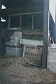
 The remains of Bowes railway station in 1996. | |
| Location | Bowes, County Durham England |
| Platforms | 2 |
| Other information | |
| Status | Disused |
| History | |
| Original company | SD&LUR |
| Pre-grouping | North Eastern Railway |
| Key dates | |
| 8 August 1861 | Opened |
| 22 January 1962 | Closed |
Bowes railway station was situated on the South Durham & Lancashire Union Railway between Barnard Castle and Kirkby Stephen East.
History[]
The line was opened on 26 March 1861 when a mineral train was run, the line opened to passengers on 8 August 1861 following an opening ceremony the day before.[1][2]
The station served the village of Bowes. The station was host to a camping coach in 1933 and from 1937 to 1939 and possibly also in 1934.[3]
The station was closed by British Railways North Eastern Region on 22 January 1962.[4]
The site today[]
The station buildings are now (2008) in an extreme state of dereliction. A large farm shed covers a portion of the platforms and yard.
The signal box, which for many years after closure was hidden away inside the farm shed, was dismantled and is in storage.[5]
The trackbed westwards of the station (towards Stainmore Summit) is covered by the re-aligned A66 road.
Images[]
Bowes signal box in 1996.
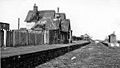
The station in 1965


| Preceding station | Disused railways | Following station | ||
|---|---|---|---|---|
| Barras | South Durham & Lancashire Union Railway | Lartington |
References[]
- ^ Quick 2019, p. 85.
- ^ "Stockton and Darlington Railway Company. Opening of the South Durham Line, between Barnardcastle and Tebay". Durham Chronicle. 9 August 1861. p. 4. Retrieved 1 June 2020. – via britishnewspaperarchive.co.uk (subscription required)
- ^ McRae 1997, p. 10.
- ^ Quick 2019, p. 63.
- ^ http://disused-stations.org.uk/b/bowes/index.shtml
Bibliography[]
- McRae, Andrew (1997). British Railway Camping Coach Holidays: The 1930s & British Railways (London Midland Region). Scenes from the Past: 30 (Part One). Foxline. ISBN 1-870119-48-7.
- Quick, Michael (2019) [2001]. Railway passenger stations in Great Britain: a chronology (PDF) (5th ed.). Railway and Canal Historical Society.
Further reading[]
- British Railways Pre-Grouping Atlas And Gazetteer. Ian Allan Publishing. 1997 [1958]. ISBN 0-7110-0320-3.
- Butt, R.V.J. (1995). The Directory Of Railway Stations. Patrick Stephens Limited. ISBN 1-85260-508-1.
- Walton, Peter (1992). The Stainmore & Eden Valley Railways. Oxford Publishing Co. ISBN 0-86093-306-7.
External links[]
- Gallery of photos of Bowes station in its current state
- More photos of Bowes station, past & present
- Photos of Bowes station in 1973
Coordinates: 54°31′11″N 2°00′27″W / 54.5197°N 2.0076°W

This article about a County Durham building or structure is a stub. You can help Wikipedia by . |
This article on a railway station in North East England is a stub. You can help Wikipedia by . |
- South Durham and Lancashire Union Railway
- Disused railway stations in County Durham
- Former North Eastern Railway (UK) stations
- Railway stations in Great Britain opened in 1861
- Railway stations in Great Britain closed in 1962
- Ruins in County Durham
- 1861 establishments in England
- Bowes
- County Durham building and structure stubs
- North East England railway station stubs