Brandenberger Ache
| Brandenberger Ache | |
|---|---|
 | |
| Location | |
| Countries | Germany and Austria |
| States | Bavaria and Tyrol |
| Physical characteristics | |
| Source | |
| • location | Spitzingsee |
| Mouth | |
• location | Inn |
• coordinates | 47°26′48″N 11°53′52″E / 47.4468°N 11.8977°ECoordinates: 47°26′48″N 11°53′52″E / 47.4468°N 11.8977°E |
| Length | 37.8 km (23.5 mi) [1] |
| Basin size | 283 km2 (109 sq mi) [1] |
| Basin features | |
| Progression | Inn→ Danube→ Black Sea |

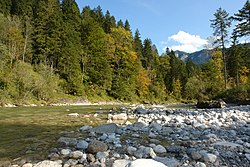
The Brandenberger Ache is a river of Bavaria, Germany, and of the Kufstein District, Tyrol, Austria.
It is a 38 km (24 mi) long left tributary of the Inn. It starts as the outflow of the Spitzingsee in southern Bavaria, and flows from North to South to the town of Rattenberg where it merges with the Inn.
References[]
- ^ Jump up to: a b Complete table of the Bavarian Waterbody Register by the Bavarian State Office for the Environment (xls, 10.3 MB)
| Authority control |
|---|
This Tyrol location article is a stub. You can help Wikipedia by . |
Categories:
- Tributaries of the Inn
- Rivers of Bavaria
- Rivers of Tyrol (state)
- Brandenberg Alps
- Rivers of Austria
- Rivers of Germany
- International rivers of Europe
- Tyrol geography stubs
- Austria river stubs
- Bavaria river stubs