Brebes, Brebes
This article needs additional citations for verification. (July 2020) |
Brebes District
Kecamatan Brebes | |
|---|---|
 Sights in Brebes (clockwise from top) : Randusanga Beach, Ciblon Waterboom, Alun alun Brebes, Great Mosque of Brebes, Karangbirahi Stadium | |
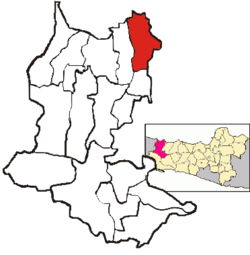 Location Brebes District in Brebes Regency | |
| Coordinates: 6°52′30″S 109°03′10″E / 6.87500°S 109.05278°ECoordinates: 6°52′30″S 109°03′10″E / 6.87500°S 109.05278°E | |
| Country | Indonesia |
| Province | Central Java |
| Regency | Brebes |
| Government | |
| • Camat | M. Amrin Alfi Umar, S.IP, M.Si[1] |
| Area | |
| • Total | 92.23 km2 (35.61 sq mi) |
| Population (2020 Census)[2] | |
| • Total | 182,421 |
| • Density | 2,000/km2 (5,100/sq mi) |
| Time zone | UTC+07.00 (WIB) |
| Postal Code | 52211 to 52220, 52251 |
| Area code(s) | 0283 |

Brebes District is a district (Indonesian: Kecamatan) and the capital of Brebes Regency, Central Java, Indonesia. It is bordered by Java Sea to the north, Tegal City (West Tegal District and ) and Tegal Regency (Dukuhturi District and Adiwerna District) to the east, Jatibarang District to the south and Wanasari District to the west. It covers 92.23 km2 and had a population of 157,149 at the 2010 Census[3] and 182,421 at the 2020 Census.[4]
Administrative Villages[]
Brebes District is divided into 23 (5 kelurahan and 18 desa).
Desa[]
Kelurahan[]
References[]
- ^ Ita (3 May 2015). "4.491 Relawan Kader Pendata Mulai Lakukan Pendataan Keluarga" (in Indonesian). Vimanews. Retrieved 12 May 2015.
- ^ Badan Pusat Statistik, Jakarta, 2021.
- ^ Biro Pusat Statistik, Jakarta, 2011.
- ^ Badan Pusat Statistik, Jakarta, 2021.
This Central Java location article is a stub. You can help Wikipedia by . |
Categories:
- Brebes Regency
- Districts of Central Java
- Central Java geography stubs