Brecon Beacons
This article needs additional citations for verification. (April 2016) |
| Brecon Beacons | |
|---|---|
IUCN category V (protected landscape/seascape) | |
| Location | Powys, Wales, United Kingdom |
The Brecon Beacons (Welsh: Bannau Brycheiniog, IPA: [ˈbanai̯ brəˈχəi̯njɔɡ]) are a mountain range in South Wales.[1] In a narrow sense, the name refers to the range of Old Red Sandstone peaks which lie to the south of Brecon. Sometimes referred to as "the central Beacons" they include South Wales' highest mountain, Pen y Fan.[2] The range forms the central section of the Brecon Beacons National Park (Parc Cenedlaethol Bannau Brycheiniog), a designation which also encompasses ranges both to the east and the west of "the central Beacons". This much wider area is also commonly referred to as "the Brecon Beacons", and it includes the Black Mountains to the east as well as the similarly named but quite distinct Black Mountain to the west. The highest peaks include Fan Brycheiniog to the west and Pen y Fan in the central part. They share the same basic geology as the central range, and so exhibit many similar features, such as the north-facing escarpment and glacial features such as lakes and cwms (cirques)
Geography[]
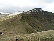
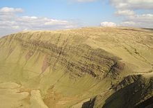
The Brecon Beacons range, in its narrower sense comprises six main peaks: from west to east these are: Corn Du, 873 metres (2,864 ft), Pen y Fan, the highest peak, 886 metres (2,907 ft), Cribyn, 795 metres (2,608 ft), Fan y Bîg, 719 metres (2,359 ft), Bwlch y Ddwyallt, 754 metres (2,474 ft), and Waun Rydd 769 metres (2,523 ft). These summits form a long ridge, and the sections joining the first four form a horseshoe shape around the head of the Taf Fechan, which flows away to the southeast. To the northeast of the ridge, interspersed with long parallel spurs, are four cwms, four round-headed valleys or cirques; from west to east these are , , and .
The Brecon Beacons are said to be named after the ancient practice of lighting signal fires (beacons) on mountains to warn of attacks by invaders.[citation needed]
The round of the Taf Fechan skyline forms a ridge walk commonly known as the Beacons Horseshoe.
Geology[]
The mountains are formed from Old Red Sandstone which dates from the late Silurian and Devonian times.
History[]
The area was inhabited during the Neolithic and the succeeding Bronze Age, the most obvious legacy of the latter being the numerous burial cairns which adorn the hills of the centre and west of the National Park. There are especially good examples of round barrows on Fan Brycheiniog, Pen y Fan and Corn Du.[citation needed] The former was excavated in 2002–4 and the ashes in the central cist dated to about 2000 BCE using radiocarbon dating. A wreath of meadowsweet was likely placed in the burial.[citation needed]
Over twenty hillforts were established in the area during the Iron Age.[citation needed] The largest, and indeed the largest in South Wales, were the pair of forts atop y Garn Goch near Bethlehem, Carmarthenshire – y Gaer Fawr and y Gaer Fach – literally "the big fort" and "the little fort".[citation needed] The forts are thought to have once been trading and political centres.
When the Romans came to Wales in 43 CE, they stationed more than 600 soldiers in the area.[citation needed] Y Gaer, near the town of Brecon was their main base. During the Norman Conquest many castles were erected throughout the park. One of the most famous is Carreg Cennen Castle but there are many more. Brecon Castle is of Norman origin.[citation needed]
There are many old tracks which were used over the centuries by drovers to take their cattle and geese to market in England. The drovers brought back gorse seed, which they sowed to provide food for their sheep.[3]
The area played a significant role during the Industrial Revolution as various raw materials including limestone, silica sand and ironstone were quarried for transport southwards to the furnaces of the industrialising South Wales Valleys.[citation needed]
The Brecon Beacons National Park[]

The Brecon Beacons are one of four ranges of mountains and hills in South Wales which make up the Brecon Beacons National Park. The National Park was established in 1957, the third of the three Welsh parks after Snowdonia in 1951 and the Pembrokeshire Coast National Park in 1952.
Mountain rescue[]
Mountain rescue in south Wales is provided by five volunteer groups, with the police having overall command. In serious situations they are aided by RAF helicopters from RAF Chivenor or RAF Valley. The five groups are:
- CBMRT – Central Beacons Mountain Rescue Team
- BMRT – Brecon Mountain Rescue Team
- LMRT – Longtown Mountain Rescue Team based in the east
- WBMSART – Western Beacons Mountain Search and Rescue Team
- SARDA South Wales – Search and Rescue Dog Association covering South and Mid Wales
The groups are funded primarily by donations. Their work is not restricted to mountain rescue – they frequently assist the police in their search for missing or vulnerable people in the community.
Military training[]
The Brecon Beacons are used for training members of the UK armed forces and military reservists. The Army’s Infantry Battle School is located at Brecon,[4] and the Special Air Service (SAS) use the area to test the fitness of applicants.[5] In July 2013 three soldiers died from overheating or heatstroke on an SAS selection exercise. An army captain had been found dead on Corn Du earlier in the year after training in freezing weather for the SAS.[4]
See also[]
References[]
- ^ "Welcome to Brecon Beacons National Park". Lonely Planet. Retrieved 20 July 2020.
- ^ "10 great places to have a staycation in the UK this year". Independent. Retrieved 20 July 2020.
- ^ Davies, Andy; Whittaker, David (2010). Walking on the Brecon Beacons. Cicerone Press. p. 139. ISBN 978-1-85284-554-4.
- ^ Jump up to: a b Farmer, Ben (14 July 2013). "Two soldiers die in heat while training in Brecon Beacons". The Telegraph. Retrieved 14 January 2015.
- ^ Farmer, Ben (2 July 2014). "No SAS manslaughter charges over Brecon Beacons deaths". The Telegraph. Retrieved 14 January 2015.
External links[]
| Wikivoyage has a travel guide for Brecon Beacons. |
- Tourist Information Brecon Beacons Park, Official Brecon Beacons Tourism Association

- IUCN Category V
- Brecon Beacons
- Landforms of Merthyr Tydfil County Borough
- Landforms of Powys
- Dark-sky preserves in the United Kingdom
- Mountain ranges of Wales
- Mountain ranges of the Brecon Beacons National Park