Briar Hill (Michigan)
| Briar Hill (Michigan) | |
|---|---|
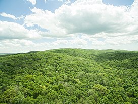 Briar Hill (1,706 ft) is the highest point in the lower peninsula of Michigan | |
| Highest point | |
| Elevation | 1,706 ft (520 m) |
| Prominence | 1,041 ft (317 m) |
| Coordinates | 44°21′58″N 85°40′46″W / 44.36619°N 85.67937°WCoordinates: 44°21′58″N 85°40′46″W / 44.36619°N 85.67937°W |
| Geography | |
| Country | United States |
| State | Michigan |
| Counties | Wexford |

Briar Hill, at 1,706 ft, is the highest point[1] in the Lower Peninsula of Michigan. It is entirely within the Manistee National Forest. The area was carved out during the last ice age, and retreating glaciers left large deposits of sand, which created Briar Hill and the nearby Caberfae Hills.
The region is subject to heavy lake-effect snow from Lake Michigan.[2] No official weather records are maintained on the hill. Fauna in the area includes black bears, coyotes, fisher, marten, mink, white-tailed deer, gray and red foxes, porcupines, river otters and beavers. Access to the area requires bushwhacking as there are no marked trails.[3]
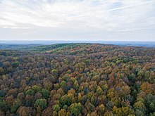
Briar Hill in October 2018
References[]
- ^ "Briar Hill, Michigan". Peakbagger. USGS. Retrieved 29 November 2017.
- ^ "Lake Effect Snow in the Great Lakes Region". U of M. GLISA. Retrieved 29 November 2017.
- ^ Dalman, Matt. "Briar Hill, Wexford County HP". summitpost. Retrieved 29 November 2017.
External links[]
This Wexford County, Michigan location article is a stub. You can help Wikipedia by . |
Categories:
- Nature reserves in Michigan
- Landforms of Wexford County, Michigan
- Lower Peninsula, Michigan geography stubs