Bridal Veil Falls (Routeburn, Otago)
| Bridal Veil Falls (Otago-Route Burn) | |
|---|---|
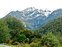 Bridal Veil as seen from the road to the Routeburn Track. | |
| Location | Queenstown-Lakes District, New Zealand |
| Coordinates | 44°42′06″S 168°14′50″E / 44.70167°S 168.24722°E |
| Type | Cascade |
| Total height | 57 metres (187 ft) |

The Bridal Veil Falls is a waterfall near Queenstown, Otago, in New Zealand. It is one of numerous streams and waterfalls in this region. This fall is only notable because it has been given a common name (Bridal Veil Falls), is clearly visible from the road and the stream from this fall runs under the third bridge of the Routeburn Track.[1] This fall is over Torlesse Terrane metamorphic rock.[2]
References[]
- ^ Bridal Veil Bridge http://www.doc.govt.nz/documents/about-doc/role/policies-and-plans/national-park-management-plans/mount-aspiring/mount-aspiring-national-park-management-plan.pdf
- ^ page 351 New Zealand Journal of Geology and Geophysics 1981 https://books.google.com/books?id=LNk4AAAAIAAJ&pg=PA357
This Otago geography article is a stub. You can help Wikipedia by . |
Categories:
- Mount Aspiring National Park
- Waterfalls of New Zealand
- Landforms of Otago
- Otago geography stubs