Bridal Veil Falls (Waikato)
| Wairēinga / Bridal Veil Falls | |
|---|---|
| Māori: Wairēinga | |
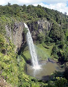 Bridal Veil Falls, as seen from the second lookout. | |
| Location | Waikato, New Zealand |
| Coordinates | 37°54′31″S 174°53′48″E / 37.908518°S 174.896636°ECoordinates: 37°54′31″S 174°53′48″E / 37.908518°S 174.896636°E |
| Type | Plunge |
| Total height | 55 metres (180 ft) |
| Watercourse | Pakoka River |

Bridal Veil Falls (officially Wairēinga / Bridal Veil Falls; Māori: Wairēinga) is a plunge waterfall located along the Pakoka River in the Waikato area of New Zealand. The waterfall is 55 m (180 ft) high, and has over time caused the formation of a large pool at the base of the waterfall. The falls are in the 217 ha (540 acres)[1] Wairēinga Scenic Reserve (created in 1884)[2] with tawa-dominated forest.[1]
Formation[]
The water cascades over a basalt cliff, formed by volcanic activity,[3] when an Okete Volcanics vent, on the 226 m (741 ft) hill just to the north, erupted about 2 million years ago and blocked the valley.[4]
Access and recreational activities[]
Approximately 15 minutes from the nearby town of Raglan, the falls are an easy 10-minute walk[5] through native bush, along the Pakoka River. Facilities include parking, long-drop toilets and four lookout platforms. River crossings are bridged. It is a steep descent to the falls base by 261 steps cut into a well maintained path.[6]
400m beyond Bridal Veil car park, where Kawhia Rd becomes gravel, is the start of the 6 km Pipiwharauroa Way walking and cycling track.
Swimming and rock climbing[]
- The pool should not be swum in as water quality does not meet health standards for swimming.
- Abseiling and rock climbing are not permitted due to damage to endangered plant life[7] (the threatened spider orchid Corybas “Kaitarakihi” (Corybas aff. rivularis)).[8]
See also[]
- Waterfall Formation
References[]
- ^ a b DoC 2013 consultation document page 97 Archived February 22, 2013, at the Wayback Machine
- ^ CW Vennell & Susan Williams (1976). Raglan County Hills and Sea 1876-1976. Wilson & Horton for Raglan County Council. p. 292. ISBN 0868640026.
- ^ Te Ara Encyclopedia - formation of waterfalls
- ^ Barry Clayton Waterhouse, P. J. White (1994). Geology of the Raglan-Kawhia Area. Institute of Geological & Nuclear Sciences (N.Z.). pp. map. ISBN 0-478-08837-X.
- ^ Tramper.co.nz
- ^ "New Stairs at Waireinga-Bridal Veil Falls". www.raglan23.co.nz. Retrieved 2016-03-25.
- ^ Department of Conservation - area guide
- ^ DoC 2013 consultation document page 97 Archived February 22, 2013, at the Wayback Machine
External links[]
- 1898 photograph in Auckland Weekly News
- Accounts of visits in 1893, before formation of the road, and in 1900
Neighbouring areas | ||||||||||||||||
|---|---|---|---|---|---|---|---|---|---|---|---|---|---|---|---|---|
| ||||||||||||||||
- Waterfalls of Waikato
- Waikato District